This Section of the EIA
Report presents the findings of an impact assessment on existing fisheries
resources, fishing operations and fish culture activities from the construction
and operation of the Proposed Beach Development. The assessment is based on the Project
Description (Section 3) and the
findings of the Water Quality Assessment (Section
6).
9.2.1
Technical
Memorandum
The criteria for
evaluating fisheries impacts are laid out in the EIAO-TM. Annex 17 of the EIAO-TM prescribes the
general approach and methodology for the assessment of fisheries impacts
arising from a project or proposal, to allow a complete and objective
identification, prediction and evaluation of the potential impacts. EIAO-TM Annex 9 recommends the criteria that
are to be used for evaluating fisheries impacts.
9.2.2
Other
Legislation
Other
legislation which applies to fisheries includes:
·
Fisheries
Protection Ordinance (Cap 171) 1987 which provides for the conservation of fish
and other aquatic life and regulates fishing practices.
·
Marine Fish
Culture Ordinance (Cap 353) 1983 regulates and protects marine fish culture
and other related activities.
·
Environmental
Impact Assessment Ordinance (cap. 499), Section 5(7) - Environmental Impact Assessment Study Brief no. CE-59/2005 (EP) Section 6.2.9 which
outlines the key fisheries impacts to be reviewed and assessed in the EIA
report.
In
9.3.1
Capture
Fisheries
In 2005,
Some recent data on the
local capture fisheries industry are shown in Table 9.1. Since 1999,
Mainland Authorities have implemented a fishing moratorium for two months
during midsummer for
Table 9.1: Hong Kong Capture Fisheries Industry Figures ([2])
|
|
1999 |
2000 |
2001 |
2002 |
2003 |
2004 |
2005 |
|
Fishing fleet size (No. of vessels) |
5,170 |
5,250 |
5,100 |
4,770 |
4,630 |
4,330 |
4,150 |
|
Portion of fishing fleet comprising
sampans (P4) and non-mechanised vessels |
44% |
51% |
54% |
53% |
No data |
No data |
No data |
|
Local fishers engaged in capture
fisheries |
12,900 |
11,900 |
11,560 |
10,860 |
10,100 |
9,770 |
9,170 |
|
Mainland deckhand employed |
6,300 |
5,200 |
4,560 |
4,100 |
3,800 |
4,090 |
4,250 |
|
Production (tonnes) |
127,780 |
157,010 |
174,000 |
169,790 |
157,400 |
167,500 |
161,960 |
|
Value of produce (HK$ million) |
1,500 |
1,600 |
1,700 |
1,600 |
1,500 |
1,600 |
1,600 |
Based
on the latest Agriculture, Fisheries and Conservation Department (AFCD) Port
Survey data (i.e. 2001/2002) ([3]),
the highest fisheries production (600 to 1,000 kg ha-1) in Hong Kong
was recorded near Cheung Chau, Penny’s Bay, Kau Yi Chau, Po Toi, Ninepin Group
and Tap Mun. The top 10 families
captured in
9.3.2
Culture
Fisheries
Culture fisheries
activities occur at 26 gazetted fish culture zones (FCZs) located in various
sheltered bays across the HKSAR and occupy about 209 ha of sea area. Fish farms
are typically small scale, family-run operations that consist of one or two
rafts with an average size of about 260m2. In 2006, there were 1,080 licensed operators
at these FCZs ([4]). Since June 2002, operators have been allowed
to transfer licences following an amendment to the Marine Fish Culture
Ordinance. According to the latest available information, in 2006 the annual
production by the marine fish culture industry was about 1,488 tonnes of fish
valued at HK$89 million and catering for about 7.9% of local demand for live
marine fish. Some recent figures on the local marine culture fisheries are
presented in Table 9.2.
Table
9.2: Hong Kong Culture Fisheries Industry Figures ([5])
|
|
1999 |
2000 |
2001 |
2002 |
2003 |
2004 |
2005 |
2006 |
|
Licensed mariculturists |
1454 |
1418 |
1320 |
1237 |
1157 |
1125 |
1104 |
1080 |
|
Production (tonnes) |
1250 |
1770 |
2470 |
1210 |
1490 |
1540 |
1540 |
1488 |
|
Value (HK$ million) |
66 |
102 |
136 |
57 |
76 |
79 |
76 |
89 |
The Study Brief has
defined the Study Area as all areas within 500m distance from the Proposed
Beach Development and any other areas likely to be impacted. It also specified special attention be paid
to the Yim Tin Tsai (East) Fish Culture Zone.
A desktop literature
review was conducted in order to examine the fisheries baseline conditions and
establish the importance of the area.
This review included the latest relevant fisheries baseline data
presented in AFCD’s Port Survey 2001/2002 and incorporated the most recent
information available in other reports and publications.
The importance of
potentially impacted fishing resources and fisheries operations identified
within the Study Area was assessed using the approach described in the
EIAO-TM. The potential impacts due to
the construction and operation of the Project and associated developments were
then assessed (with reference to the EIAO-TM Annex 17 guidelines) and the
impacts evaluated (with reference to the criteria in EIAO-TM Annex 9).
9.5.1
Capture Fisheries
Fishing Vessels
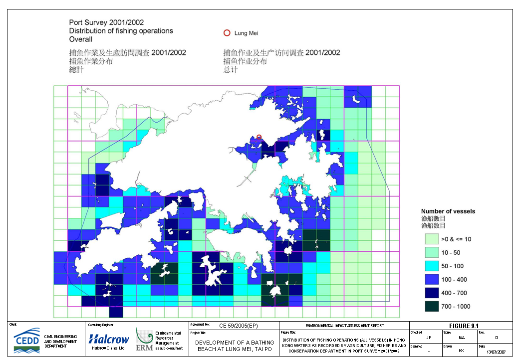
The
overall number of fishing vessels that operated in 2001 and 2002 in the waters
adjacent to the Proposed Beach Development is presented in Figure 9.1 ([6]). It was reported that there were approximately
100 to 400 fishing vessels that operated in the waters adjacent to Lung
Mei. Of these, the majority of the
vessels were sampans (100 – 400 vessels).
The only other vessels types to operate in these waters were gill-netters
and purse seiners, which were reported to number less than 10 vessels
each. No trawlers were reported to
operate within 500m of the project boundary, presumably on account of the
shallow nature of the water and because the area is obstructed to a certain
degree by moored leisure craft.
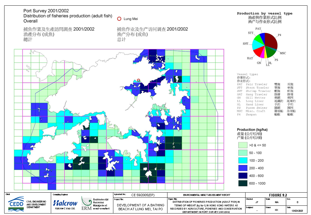
Fisheries
Production
Adult Fish by Weight: With reference to the
grid system developed by AFCD (Figure 9.2),
about 100 - 200 kg ha-1 of adult fish production was recorded in
2001 and 2002 around the Proposed Beach Development, which is considered to be
low to medium level compared to other
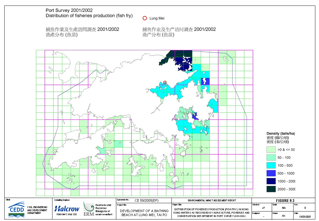
Fish Fry by Weight: A moderate level of fish
fry production (100 - 500 tails ha-1) was reported from around Lung Mei as is the case throughout the
Tolo embayment (Figure 9.3). Fish fry
production is used to supply grow out stock for the mariculture industry.
Adult Fish & Fish Fry by Value: Based on the AFCD
2001/2002 Port Survey data, the overall catch value of both adult fish and fish
fry recorded for the waters surrounding the Proposed Beach Development was in
the range of HK$ 2000 – 5000 (Figure 9.4)
whereas the value was in the range of HK$ 5000 – 10,000 in most of the areas
within Tolo Harbour outside the Proposed Beach Development. Compared to other
Spawning
and Nursery Areas
The waters surrounding
Lung Mei do not coincide with areas previously identified in the literature as
important nursery or spawning grounds for commercial fisheries resources. Outside the 500m Study Area and approximately
3km from the project boundary, the waters of the Tolo Channel are reported to
be part of a nursery area for commercial fisheries resources which covers a
swathe of Hong Kong northeast waters spanning Tolo Harbour and part of Mirs Bay
([7]). This nursery area is located sufficiently
remote from the Proposed Land Requirement Boundary as to not be affected by the
works.
9.5.2
Culture Fisheries
The
closest designated Fish Culture Zone (FCZ) to the Study Area is located
approximately 1.5km to the south of the project boundary at Yim Tin Tsai
East. This FCZ of 149,500m2,
has 289 licensed rafts in a licensed area of 20,556m2 and which are
operated under 81 licences ([8]).
Although there are other
FCZs located around the Tolo embayment (eg Yim Tin Tsai, Kau Lau Wan, Lo Fu
Wat, Sham Wan, Tap Mun and Yung Shue Au), their location is sufficiently remote
that they would not be affected by the project works.
Although there are no
figures available for individual production of designated FCZs, it is known
that the main species cultured in
9.5.3
Proposed Fisheries
Protection Area
A Fisheries Protection
Area has been proposed under the Fisheries Protection Ordinance which
encompasses most of the Tolo embayment and includes Plover Cove where Lung Mei
is located. Although designated to
provide specific controls on fishing activities, the area can be regarded as a
sensitive water body and any impacts should be minimised as far as possible
during construction to achieve compliance with the Water Quality Objectives or
Assessment Criteria.
9.5.4
Fisheries Importance
The importance of the
fisheries resources within the Study Area is addressed based on the baseline
information provided above. The fishing
areas within
9.5.5
Fisheries Sensitive
Receivers
Based on the information
review presented above on the fisheries resources of the Study Area and its
immediate vicinity, the sensitive receivers which may be potentially affected
by the proposed project are:
·
Yim Tin Tsai East Fish Culture Zone; and,
·
Proposed Fisheries Protection Area.
9.6.1
Identification of
Potential Impacts
Construction Phase
The construction
activities associated with the Proposed Beach Development that have the
potential to cause impacts to fisheries are:
·
Dredging
associated with groynes and box culverts construction;
·
Dredging
associated with beach development; and
·
Sandfilling
associated with the groynes construction and beach development.
The construction of the
Proposed Beach Development will involve dredging in the beach area and at the
box culverts as well as sand filling in the beach area. Overall, the dredging level will vary between
0.5m to 1m at the proposed beach area and groynes, and less than 3m at the box
culverts, subject to the bathymetry of the existing seabed.
Construction phase
impacts to fisheries resources and fishing operations arising from the
construction works of the proposed beach may be divided into those due to
direct disturbances to that habitat and those due to indirect perturbations to
key water quality parameters.
Direct
Impacts
Up to 5.4ha of existing
seabed will be affected as the result of dredging works and be replaced by sand
materials and designated as gazetted beach after 2010, in which only
approximately 4.7ha is defined as the beach area during operation (between the
high tide mark of the shoreline and the shark prevention net). The marine work activities will also be
restricted within the project and works area (up to 5.4ha) which may restrict
the fishing operation. Occupation
of the foreshore area by such marine works will cause a temporary loss of
fishing ground, which does not cause any significant adverse impacts on local
fisheries. The bathymetry of the existing beach
is less than 1m close to the shore to approximately 5m at the outward boundary
of the proposed beach. Due to the small
area of the marine habitat permanently lost for the beach development, the
adverse impacts to local fisheries resources are not predicted to be
significant. It should be noted that the
proposed beach is not a suitable fishing ground for trawling types of fishing
vessels due to its shallow nature of water and the area is obstructed to a
certain degree by moored leisure craft.
According to the fishing
activities information published by AFCD (Figures
9.1 – 9.4), the Proposed Beach Development at Lung Mei has a lower
fisheries production value (adult and fish fry) than most of the other areas
within
In view of the relative
small area of the loss of fisheries habitat which has a lower fisheries
production value at the Proposed Beach Development than other areas within
Indirect Impacts
Indirect impacts to
fisheries resources and fishing operations during the construction phase are
primarily associated with the suspension of sediments due to the marine
works. Potential impacts to water quality
from sediment release are listed below:
·
Increased concentrations of suspended
solids (SS);
·
Increased turbidity and a resulting
decrease in dissolved oxygen (DO) concentrations;
·
Increase in nutrient concentrations in the
water column; and
·
Release of heavy metals and toxic chemicals
from the sediment.
Suspended Solids: Suspended solids (SS) fluxes occur naturally
in the marine environment ([9]);
consequently, fish have evolved behavioural adaptations to tolerate changes in
SS load (e.g., clearing their gills by flushing water over them). However, the increase in SS concentrations
that would arise from the dredging would be uncharacteristic of the normal
variation in marine conditions.
Concentrations of SS generated via dredging are expected to be greater,
particularly in the immediate vicinity of the dredger. Beyond the active dredging area, dispersion
will cause a rapid decrease in the SS concentrations.
Larvae and post-juvenile
fish are more susceptible to variations in SS concentrations than more mature
fish since their sensory system is less developed. Adult fish are more likely to move away when
they detect sufficiently elevated SS concentrations and therefore are unlikely
to be significantly impacted. Larvae and
post-juvenile fish are more likely to be impacted as they may not be able to
detect and avoid areas with elevated levels of SS.
The
SS level at which fish move into clearer water is defined as the tolerance
threshold and varies from species to species at different stages of the life
cycle. If SS levels exceed tolerance
thresholds and the fish are unable to move away from the area, the fish are
likely to become stressed, injured and may ultimately die. Susceptibility to SS generally decreases with
age such that eggs are the most vulnerable and adults the least sensitive to
the effects of high SS concentrations.
The rate, timing and duration of SS elevations will influence the type
and extent of impacts upon fish and potentially crustaceans ([10])
([11]).
Literature
reviews indicate that lethal responses had not been reported in adult fish at
values below 125 mg L-1 ([12])
and that sublethal effects were only observed when levels
exceeded 90 mg L-1 ([13]). However, guideline values have been
identified for fisheries and selected marine ecological sensitive receivers as
part of the study for AFCD, Consultancy
Study on Fisheries and Marine Ecological Criteria for Impact Assessment ([14]). The values are based on international marine
water quality guidelines for the protection of ecosystems. No Water Quality Objective for SS was
established in
Temporarily
elevated levels of SS are likely to occur in the immediate vicinity of the
marine works (see Section 6 - Water
Quality Assessment). However, the mixing
zones during the dredging and sandfilling works in marine water are small and
localised. There are no predicted
exceedances of the assessment criteria (50 mg L-1) at the sensitive
receivers including at the Yim Tin Tsai East Fish Culture Zone (Highest
predicted SS level at the nearest EPD’s monitoring station (TM5) is 8 mg L-1)
as a result of the beach construction works.
As a precautionary measure, silt curtain will be provided during the
dredging and sandfilling works in marine water to further minimise the
potential impact that may arise.
Dissolved Oxygen: The relationships between
SS and DO are complex, with increased SS in the water column combining with a
number of other effects to reduce DO concentrations. Elevated SS (and turbidity) reduces light
penetration, lowers the rate of photosynthesis by phytoplankton (primary
productivity) and thus lowers the rate of oxygen production in the water
column. Furthermore, the potential
release of sediment contaminants into the water column has the potential to consume
DO in the receiving water. The resulting
overall DO depletion may cause an adverse effect on the eggs and larvae of fish
and crustaceans, as at these stages of development high levels of oxygen in the
water are required for growth to support high metabolic growth rates.
The results of the water
quality assessment (Section 6.5.1)
examining the dispersion of sediment plumes associated with all marine works
has shown that the predicted maximum levels are localised. Concentrations at the sensitive receivers
within the Study Area will remain compliant with the assessment criteria. The subsequent effect on dissolved oxygen
within the surrounding waters is, therefore, predicted to be minimal. Unacceptable impacts to fisheries from the
reduction of DO concentration are not expected to occur.
Nutrients: High levels of
nutrients in seawater can cause rapid increases in phytoplankton, on occasions
to the point where an algal bloom occurs.
An intense bloom of algae can lead to sharp decreases in the levels of
dissolved oxygen. This decrease will
initially occur in the surface water, and then deepen as dead algae fall
through the water column and decompose on the seabed. Anoxic conditions may result if DO
concentrations are already low or are not replenished. As discussed above, reduced levels of DO can
impact the eggs and larvae of fish and crustaceans which require high levels of
oxygen for development. Significantly
low levels of DO may also result in mortality to fish.
As with dissolved oxygen,
the effect of the localised increases in suspended solid concentrations on
nutrients within the surrounding waters is expected to be minimal (see Section 6.5.1). Unacceptable impacts to fisheries are not,
therefore, anticipated.
Heavy Metals and Toxic Chemicals: The water quality assessment has shown that
unacceptable water quality impacts due to the release of heavy metals and
organic micro-pollutants associated with SS are not expected to occur (see Section 6.5.1).
The elutriate test
results (undertaken for this study in 2006) indicate that concentrations of
PAHs, total PCBs, TBT and all chlorinated pesticides were found below the
reporting limits for all sampling locations.
Moreover, the concentrations of dissolved metals in most of the samples
are compliant with the assessment criteria.
This indicates that dredging the sediments is unlikely to cause a
detectable increase in contaminant levels in the surrounding water. Unacceptable impacts to fisheries and fish
culture zone are not, therefore, anticipated.
Operation
Phase
The potential impacts of
the Operational Phase of the Project on the fisheries of the Study Area and the
sensitive receivers can be divided into two main categories:
·
Impacts arising from the altered land use due to the
presence of the beach, mainly loss of fisheries habitat and the alteration of
the natural marine hydrodynamic regime; and
·
Impacts arising from the alteration of the benthic habitat
due to the maintenance dredging and sandfilling.
As no sewage and
wastewater generated from the beach building facilities will be discharged into
the beach or marine environment, water quality impact due to sewage and
wastewater discharge is not anticipated (see Section 6).
Habitat Loss
The estimated overall
permanent loss of the existing shoreline will be approximately 200m (not more
than 4.7ha, which defined as the beach area and will not allow for any fishing
activities during operation (between the high tide mark of the shoreline and
the shark prevention net)) which is deemed to be too small to cause any
significant adverse impacts on the local fisheries.
Maintenance Dredging and
Sandfilling
Maintenance dredging is
not anticipated during the operation of the beach. Maintenance sandfilling is not anticipated in
the near future during the operation of the beach. As a result,
impacts to fisheries resources are not anticipated.
From the information presented above, the fisheries impact associated with the Proposed Beach Development is not considered to be significant. An evaluation of the impact according to Annex 9 of the EIAO-TM is presented below.
·
Nature of Impact
and Size of the Affected Area: Temporary and permanent impacts will occur as a
result of the loss of not more than 5.4 ha and 4.7 ha respectively of existing
seabed and be replaced by sand materials in the area to be used for the
proposed beach. Short-term impacts will
occur to fisheries resources in the vicinity of the works area as a result of
the dredging and sandfilling activities for the beach, groynes and box
culverts. Temporary and localised
impacts to pelagic and demersal fisheries resources as a result of
perturbations to water quality are predicted to occur only in the immediate
vicinity of the works areas. No
significant adverse impacts to fisheries resources are expected from the
construction phase of the beach and during its operation.
·
Size of
Fisheries Resources/Production: Fisheries
resources and production rates are generally medium in terms of catch weight
and value, when compared to other areas in
·
Destruction and
Disturbance of Nursery and Spawning Grounds: The waters surrounding Lung Mei do not
coincide with areas previously identified in the literature as important
nursery or spawning grounds for commercial fisheries resources. Outside the 500m Study Area and approximately
3km from the project boundary, the waters of the Tolo Channel are reported to
be part of a nursery area for commercial fisheries resources which covers a
swathe of Hong Kong northeast waters spanning Tolo Harbour and part of Mirs Bay
([15]). This nursery area is located sufficiently
remote from the project boundary as to not be affected by the works.
·
Impact on
Fishing Activity: Due to the small
size of the beach area as well as limited fishing operations, the impacts on
fishing activities are expected to be minimal.
· Impact on Aquaculture Activity: The closest designated Fish Culture Zone to the Study Area is located approximately 1.5km to the south of the project boundary at Yim Tin Tsai East. Water quality modelling results indicated that the SS and DO levels complied with the assessment criteria. Dredging the sediments is unlikely to cause a detectable increase in contaminant levels in the surrounding water. Thus adverse impacts on aquaculture activity are not anticipated.
In accordance with the
guidelines in the EIAO-TM on fisheries impact assessment, the policy adopted in
this EIA for mitigating impacts to fisheries, are:
·
Avoidance: Potential impacts should be avoided to the
maximum extent practicable by adopting suitable alternatives;
·
Minimisation: Unavoidable impacts should be minimised by
taking appropriate and practicable measures such as confining works in specific
area or season, restoration (and possibly enhancement) of disturbed fisheries
resources and habitats;
·
Compensation: When all possible mitigation measures have
been exhausted and there are still significant residual impacts or when the
impacts are permanent and irreversible, consideration shall be given to
off-site compensation. It may include
enhancement of fisheries resources and habitats elsewhere.
Construction impacts to
fisheries resources and fishing operations have largely been avoided and
minimised through the planning and design of the works; in particular those
associated with dredging and sandfilling. Dredging volume has been
substantially reduced in the design process from approximately 49,500m3
to 10,500m3, which includes the dredging for the beach area as well
as for the proposed eastern box culvert. Sandfilling volume has also been
substantially reduced from approximately 47,200m3 to 37,500m3. Silt curtain will be provided during the
dredging and sandfilling works as a precautionary measure. The main works have been designed to control
water quality impacts to within acceptable levels and hence are also expected
to control and minimise impacts to fisheries resources. No fisheries-specific
mitigation measures are required during construction.
Significant operational
phase impacts to fisheries resources and fishing operations are not expected to
occur. Sewage and wastewater generated
from the beach building facilities will be discharged into the public
sewer. No additional fisheries-specific
mitigation measures or compensation are required during operation.
The identified residual
impact occurring during the construction and operation phase is the permanent
loss of not more than 5.4ha and 4.7ha of existing seabed respectively which
will be replaced by sand materials after the completion of beach
development. Once the dredging and
sandfilling works have been completed, the fish can rehabilitate in the intertidal
part of beach area. No exceedance of
assessment criteria is anticipated at the sensitive receivers including the Yim
Tin Tsai East Fish Culture Zone during the construction works. Approximately 4.7 ha of coastal waters will
be restricted for fishing operation during the operation of the beach. Due to the small size of the affected area,
adverse impacts to fisheries are not expected to be anticipated.
Overall, the residual
impacts to fisheries during both the construction and operation phases are
considered as acceptable.
9.9.1
Construction Phase
At present, there is a committed project ‘Tolo Harbour
Sewerage of Unsewered Areas Stage 1 Phase IIC’ that could have potential
cumulative impacts with the construction of the Proposed Beach
Development. However, the wastewater
generated from the construction of the Proposed Beach Development will be
collected and treated before discharge.
No untreated discharge of wastewater will be allowed from the
construction site. For the wastewater
discharge from ‘Tolo Harbour Sewerage of Unsewered Areas Stage 1 Phase IIC’, it
is recommended that treatment/minimization of wastewater generation should be
included as part of their contractual requirements.
With the adoption of the wastewater treatment for site
runoff and the water pollution control measures described in Section 6 Water Quality Assessment,
cumulative water quality impacts to fishery resources are not anticipated
during the construction of the Proposed Beach Development.
9.9.2
Operation Phase
At present there are no
committed projects that could have cumulative impacts with the operation of the
beach. The completion of the Tolo
Harbour Sewerage of Unsewered Areas Stage 1 Phase IIC at Lung Mei and
surrounding area would further reduce the wastewater releasing into the marine
environment. Thus, cumulative impacts to
fishery resources are not anticipated during the operation of the Proposed
Beach Development.
9.10.1
Construction Phase
As no unacceptable impacts have been predicted to occur
during the construction of the beach at Lung Mei, monitoring of fisheries
resources during the construction phase is not considered necessary. However, water quality monitoring will be
conducted (see EM&A Manual Section
12.6) at the Yim Tin Tsai East Fish Culture Zone.
9.10.2
Operation Phase
As no unacceptable impacts have been predicted to occur during the operation of the beach at Lung Mei, monitoring of fisheries resources during the operation phase is not considered necessary.
Reviews of existing
information on commercial fisheries resources and fishing operations
surrounding the waters adjacent to the proposed beach have been
undertaken. Information from a study on
fishing operations in
Potential impacts to
fisheries resources and fishing operations, as well as impacts to fish fry, may
arise from the temporary and permanent loss of habitat due to dredging and
sandfilling, disturbances to benthic habitats on which the fisheries resources
depend for food, or through changes to key water quality parameters, as a
result of the marine works. Given the
small size of marine habitat lost/disturbed, the associated impacts to
fisheries resources are not considered to be unacceptable.
Impacts arising from the
proposed dredging or sandfilling works are predicted to be largely confined to
the specific works areas and the predicted elevations in suspended sediment
concentrations at the sensitive receivers including Yim Tin Tsai Fish Culture
Zone are not predicted to cause exceedances of the assessment criterion. Silt curtain will be provided during the
dredging and sandfilling works in the marine water as precautionary
measure. Adverse impacts to water quality
and consequential adverse impacts to fisheries resources are not predicted to
occur. Water quality monitoring will be
conducted at Yim Tin Tsai Fish Culture Zone during the dredging and sandfilling
works.
Significant operational phase impacts to fisheries resources
and fishing operations are not expected to occur. Approximately 4.7ha of coastal waters will
be restricted for fishing operation during the operation of the beach. Adverse impacts to fisheries are not expected
to be anticipated given the small size of the affected area. Impact from sewage and wastewater discharge
is not anticipated to occur as the sewage and wastewater generated from the
beach building facilities will be discharged into the public sewer. No additional fisheries-specific mitigation
measures are required during operation.
([1])
Data from Agriculture, Fisheries and
Conservation Department. Web site
www.afcd.gov.hk. Accessed on 28 Aug 2007.
([2])
Data from
([3])
Agriculture, Fisheries and
Conservation Department (2002). Port Survey 2001/2002. Web site
www.afcd.gov.hk. Accessed on 28 Aug 2007.
([4])
Data from Agriculture, Fisheries and
Conservation Department. Web site
www.afcd.gov.hk. Accessed on 28 Aug 2007.
([5])
Data from websites of Hong Kong
Yearbook and Agriculture, Fisheries and Conservation Depart. Op. Cit.
([7])
ERM-Hong Kong, Ltd. (1998). Fisheries
Resources and Fishing Operations in Hong Kong Waters, Final Report for
Agriculture, Fisheries and Conservation Department.
([8])
Maunsell Consultants Asia Ltd.
(2007). Drainage Improvement in Sha Tin
and Tai
([9])
Natural SS values for
([10])
Species Profiles: Life Histories and
Environmental Requirement (Gulf of Mexico) - Brown
([11])
The Shrimp Fishery of the
([12])
References cited in BCL (1994)
([13])
Alabaster JS & Lloyd R
(1984) Water Quality Criteria for Freshwater Fisheries. Butterworths,