Rivers monitored
Under ‘Eastern New Territories’ are included ten rivers across three
different Water Control Zones. They all flow into embayments in Hong
Kong’s eastern marine waters. Six of them flow into Tolo Harbour:
these are the Shing Mun River in Sha Tin, the Lam Tsuen and Tai Po
Rivers in Tai Po town centre, and Tai Po Kau Stream, Shan Liu Stream
and Tung Tze Stream in the Tai Po rural area. Another three flow into
Port Shelter in Sai Kung: the Ho Chung River, Sha Kok Mei Stream and
Tai Chung Hau Stream. The final one, Tseng Lan Shue Stream, flows into
Junk Bay near Tseung Kwan O.
 |
|
 |
|
Map of rivers monitored in the Eastern New Territories,
showing their Water Quality Index gradings in 2005 |
|
|
 |
 |
|
 |
The situation in 1986
The Water Control Zones for rivers in the Eastern New Territories were
some of the earliest appointed, set up back in the late 1980s. Part of
the reason for this was that, while these WCZs were overall not the
most seriously polluted in Hong Kong, some embayments within the WCZs
(in particular Tolo Harbour) were highly sensitive to nutrient
enrichment and algal bloom. Tolo Harbour is largely landlocked, with a
narrow channel to the open sea, making it difficult for pollutants
entering the harbour to be flushed out by tidal action. In the 1980s,
the harbour was suffering severely from red tides, so the early
establishment of the WCZs aimed to help improve harbour water quality
as well.
Pollution in the 1980s was largely the result
of untreated effluent from livestock farms and unsewered villages,
made worse as the New Towns developed by increasing numbers of
industrial and commercial premises and especially those using
expedient connections (i.e. where untreated effluent is channelled
into the stormwater drain system instead of into sewers) to dispose
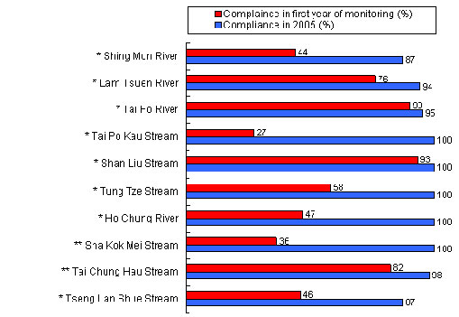
of waste. In 1986, 24% of monitoring stations in the area recorded
‘Bad’ or ‘Very Bad’ WQI gradings. Overall WQO compliance for the
area in 1986 stood at 57%. In response to this, the Government
initiated a number of improvement measures.
 |
|
 |
|
| Compliance with the Water Quality Objectives in the rivers of the Eastern New Territories in the 1980s and in 2005 |
|
|
 |
 |
*
first monitored in 1986 ** first monitored in 1989 |
 |
Perhaps the biggest initial impact on the pollution problem came with the implementation, under the Waste Disposal Ordinance, of the Livestock Waste Control Scheme in June 1988, which banned livestock farming in the new towns and urban areas and began controlling livestock farming in other areas. As a result of this scheme, by the mid 1990s no livestock farms remained in the catchment areas of any of the ten rivers in the Eastern New Territories.
The EPD also began to enforce the Water Pollution Control Ordinance as the various Water Control Zones were declared. It began enforcement activities for the Tolo Harbour and Channel WCZs (covering Sha Tin and Tai Po) from 1 April 1987, for the Port Shelter WCZ (covering Sai Kung) from 1 August 1989, and for the Junk Bay WCZ (covering Tseung Kwan O) also from 1 August 1989.
These enforcement activities typically
involved the EPD issuing discharge licences and checking effluent
quality against the limits specified by the licences. Factories, for
example, were required to apply for discharge licences from the EPD,
comply with all the terms and conditions for discharge, and divert
their effluent to sewers after appropriate treatment. The EPD also
searched for expedient connections and, on finding them, tracked
down those responsible and required them to put things right.
Overflow from poorly maintained septic tanks
and dirty water from kitchens and bathrooms in unsewered villages
were also causing considerable pollution problems in some rivers,
especially following heavy rain. The EPD conducted regular
inspections, and provided householders with advice on maintaining
their septic tanks.
 |
The Ho Chung River is one where water quality has benefited from dry weather flow interceptors |
|
One way to help minimise
pollution even before all expedient connections have been eliminated
and a comprehensive sewerage system put in place is to build dry
weather flow interceptors below pollution sources. As their name
implies, dry weather flow interceptors function to intercept polluted
effluent flow and divert it to sewers and thence to treatment plants.
Since 1992, such interceptors have been installed in Sha Tin, Tai Po
and Sai Kung to reduce the effects of pollution.
However, dry weather flow interceptors are only
interim measures. As is always the case, it is improved sewerage that
makes the biggest difference to river water quality. A number of
recommendations made in the Tolo Harbour and Port Shelter Sewage
Master Plans began to be carried out in 1993. As a result, more than
70 unsewered villages and other areas in the Eastern New Territories
were provided with public sewers in 2005, with more than 4,000 village
houses being connected.
 |
|
 |
|
Water Quality Index gradings for rivers in the
Eastern New Territories, 1986 and 2005 |
|
|
|
 |
|
 |
All these initiatives had a significant effect
on river water quality in the area. As the accompanying chart shows,
not a single monitoring station in 2005 had water graded as ‘Bad’ or
‘Very Bad’, and nearly three quarters of all monitoring stations
recorded ‘Excellent’ grades. Overall WQO compliance for the year 2005
had risen to 93%, from the 57% of two decades earlier.
WQO compliance has not yet reached 100%,
largely because of the number of unsewered villages that still remain
scattered across the area. Village sewage has also resulted in fairly
high E. coli levels at some of the monitoring stations (>10,000
cfu/100 mL). Under the various Sewerage Master Plans, the Government
will further extend the public sewer network to unsewered areas over
the next decade. The tables below give further details of the
schedules for implementing sewerage projects in the area.
 |
|
 |
|
| Schedule for implementing village sewerage projects under the Tolo Harbour Sewerage Master Plan and its Review |
|
|
Sewerage Projects |
Status (Schedule) |
Capacity
(in terms of population) |
Coverage |
Stage I Phase I |
Completed
(1993 - 2004) |
34,000 |
43 unsewered villages /areas in Sha Tin and Tai Po |
Stage I Phase II |
In progress
(1998 - 2011) |
47,000 |
47 unsewered villages /areas in Sha Tin and Tai Po |
Stage II |
Planned
for completion by 2014 |
19,000 |
41 unsewered villages /areas in Sha Tin and Tai Po |
Lam Tsuen Valley Sewerage |
Planned
for completion by 2013 |
20,000 |
Unsewered villages in Lam Tsen Valley |
|
 |
|
 |
 |
|
 |
|
| Schedule for implementing village sewerage projects under the Port Shelter Sewerage Master Plan and its Review |
|
|
Sewerage Projects |
Status (Schedule) |
Capacity
(in terms of population) |
Coverage |
Stage I |
Completed
(1993 - 2001) |
9,800 |
4 unsewered villages /areas in Sai Kung |
Stage II |
In progress
(1995 - 2013) |
37,200 |
27 unsewered villages /areas in Sai Kung |
Stage III |
Planned for completion by
2013 |
21,300 |
5 unsewered villages /areas in Sai Kung |
|
 |
|
 |
Case study: the Shing Mun River
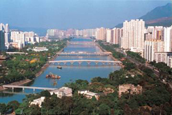 |
The Shing Mun River is the largest river in the Eastern New Territories |
|
To get a detailed look at the
problems facing the Eastern New Territories area and the kind of
improvements that have been achieved over the past twenty years, the
case of the Shing Mun River is well worth closer study. Flowing
through the heart of Sha Tin and out into Tolo Harbour through the
Shing Mun Channel, the river has a catchment area of 37 square
kilometres, the largest in the Eastern New Territories. Its major
tributaries include the Kwun Yam Shan Stream, Tin Sum Nullah, Fo Tan
Nullah, Tai Wai Nullah and Siu Lek Yuen Nullah. The lower reach of the
Shing Mun Main Channel was originally a part of Tolo Harbour, but
reclamation transformed it into a river channel. Improved water
quality in recent years has made the Main Channel popular for rowing
and other kinds of boating events, such as dragon boat races.
Back in the 1980s, however, the Shing Mun River
was not for the fainthearted. It was severely polluted from industrial
and commercial effluent, discharge from livestock farms, runoff from
unsewered villages, and effluent entering through expedient
connections in the new towns. Its most polluted branches were the Tai
Wai, Fo Tan and Siu Lek Yuen Nullahs, all of whose water quality was
consistently graded ‘Bad’, with black water and foul-smelling
sediment. The first two of these nullahs were primarily polluted
through expedient connections from commercial, industrial and domestic
premises, while the third took the brunt of livestock farms in its
vicinity. The Main Channel of Shing Mun River was slightly better,
graded ‘Fair’, but it suffered from the pollution load coming from its
tributaries, and its self-cleansing capabilities were limited due to
its very weak flow in the intertidal area. Little or no aquatic life
could be found in the Shing Mun River at this period.
With the establishment of the
Tolo Harbour and Channel Water Control Zone on 1 April 1987, the EPD
was empowered to control water pollution in the zone. Anyone
discharging effluent was required to first give it proper treatment.
The EPD also began surveys of expedient connections in Sha Tin and the
surrounding area. As a result of these surveys and the EPD’s follow-up
actions, many of the expedient connections were removed, especially
those flowing into the Tai Wai and Fo Tan Nullahs. The improvement in
water quality was dramatic. In particular, since Fo Tan is an
industrial area, industrial pollutants such as heavy metals were
significantly reduced. The accompanying graph, for example, shows the
huge decrease in the concentration of copper in the Fo Tan Nullah
between 1989 and 1990, and the low level that has been maintained ever
since.
As mentioned earlier, when
the Livestock Waste Control Scheme began on 24 June 1988 many farmers
in urban areas were required to close down their farms. The Shing Mun
River received livestock effluent primarily through the Siu Lek Yuen
Nullah, and the new legislation led to immediate improvements in water
quality that were noted in 1989. These improvements continued over the
next six years until, by 1996, all livestock operations in the area
had ceased. The graph shows the marked reduction of total Kjeldahl
nitrogen (i.e. ammonia and organic nitrogen arising primarily from
livestock waste) in the Siu Lek Yuen Nullah from 1989.
The third key polluting element affecting the
Shing Mun River was waste water discharged from dozens of unsewered
villages in the river’s catchment area. Most of these village houses
treated their effluent using primitive septic tanks that tended to
leak or overflow after heavy rain.
 |
|
 |
|
E. coli levels in Shing Mun
Main Channel (TR19I) |
|
|
|
 |
|
 |
The ultimate solution to the
village pollution problem is the provision of public sewerage and the
commitment of village house owners to properly connect their houses to
the sewer network once it becomes available. Since 1992, dry weather
flow interceptors have been constructed as an interim measure
downstream of some key villages, to intercept polluted flows and
direct them into sewers. Around 30 villages in the Shing Mun catchment
area had the public sewer extended to them under Stage I of the Tolo
Harbour Sewerage Master Plan. More than 1,500 village houses (housing
a population of around 11,000) were connected to public sewers between
1996 and 2005, and the collected sewage piped to the Sha Tin Sewage
Treatment Works for treatment. As for villages still not served by the
public sewer network, the dry weather flow interceptors are continuing
to serve their purpose, and the EPD has been active in offering
villagers advice on how to properly maintain their septic tanks so as
to minimise pollution risks. The result of all these initiatives has
been an improvement of water quality and a steady decline in E.
coli levels in the Shing Mun River, as the graph shows.
Because the intertidal Main Channel of the
Shing Mun River suffers from a very weak flow, pollutants have tended
to build up in the sediment, leading to low levels of dissolved
oxygen. This in turn created an odour problem, the distinctive ‘bad
smell’ of unhealthy water. To help overcome this problem, the Shing
Mun River Improvement Works were carried out between 2001 and 2005.
The project improved the quality of the sediment in Shing Mun River,
both by dredging out contaminated sediment and by applying a
bioremediation method. Today, the river is far less demanding on the
nose! Fish and other water life can be found all along the river.
Apart from boating, many residents now take pleasure in strolling,
cycling and fishing along the banks of the Shing Mun River.
The effectiveness of all these measures is
shown by some simple statistics. The overall WQO compliance of the
Shing Mun River improved from 42% in 1987 to around 87% in 2005, in
which year each of the ten monitoring stations for the river also
achieved WQI grades of either ‘Good’ or ‘Excellent’.
Plans have been made to extend the public sewer
network to a further ten or more villages in the Shing Mun catchment
area, and some of this work is now in progress. The river water
quality should further improve once more village houses are connected
to the public sewer.
Survey of Tai Po rivers
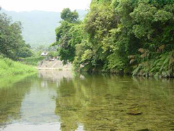 |
The Lam Tsuen River’s upstream reaches are used as water gathering grounds |
|
The EPD monitors five rivers
in or around Tai Po. Two of them are major rivers: the Lam Tsuen
River, which flows down the Lam Tsuen Valley into Tai Po Town Centre,
and the Tai Po River which flows northward from Ta Tit Yan. The two
rivers join in the town centre before flowing into the western part of
Tolo Harbour. The other three watercourses are minor streams in the
rural outskirts of Tai Po: Tai Po Kau Stream in Tai Po Kau, and the
Shan Liu and Tung Tze Streams in Shuen Wan.
These rivers all suffered similar problems to
the Shing Mun River in the 1980s, though to a lesser extent.
Improvements arose from the same initiatives discussed above. In the
1980s, five of the 13 monitoring stations were graded between ‘Very
Bad’ and ‘Fair’, but by 2005 they had all attained either ‘Excellent’
or ‘Good’ WQI grades. All rivers monitored in Tai Po achieved WQO
compliance of over 90%. As with the Shing Mun River, river water
quality will further improve as more village houses are connected to
the public sewer once it is extended.
Survey of Sai Kung rivers
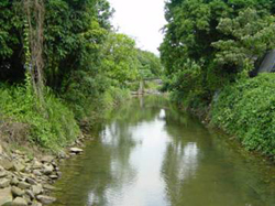 |
The Tai Chung Hau Stream flows into Port Shelter |
|
The three rivers monitored in
Sai Kung are the Ho Chung River, Sha Kok Mei Stream and Tai Chung Hau
Stream, situated in the catchments of the same names. Sai Kung is a
largely rural district, and most villages in the hinterland are
unsewered. As a result, pollution affecting these rivers in the 1980s
mainly came from unsewered villages and livestock farms, along with a
few factories. In the late 1980s, four of the six monitoring stations
had WQI grades of between ‘Fair’ and ‘Very Bad’. The initiatives
described earlier saw improvements to the extent that by 2005 all
monitoring stations were graded ‘Excellent’, and all three rivers had
achieved WQO compliance of between 98% and 100%. Sewerage projects
under the Port Shelter Sewerage Master Plan are being implemented in
phases, and as these are completed there should be further gradual
improvements in water quality.
Survey of a Tseung Kwan O watercourse
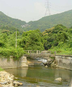 |
The lower reaches of the Tseng Lan Shue Stream |
|
There is only one watercourse
in Tseung Kwan O monitored by the EPD, the Tseng Lan Shue Stream. Most
of its catchment is unsewered, and in the late 1980s its three
monitoring stations recorded WQI grades of between ‘Fair’ and ‘Very
Bad’. By 2005, following the various initiatives described above, the
gradings of the stations ranged between ‘Fair’ and ‘Excellent’. The
upstream monitoring station (JR3), located near the village of Tseng
Lan Shue, was graded ‘Fair’ in 2005. Interestingly, this stream gets
better as it goes down. The watercourse falls steeply in mid-stream,
creating strong aeration which aids the river’s self-cleansing
abilities. Downstream, monitoring stations for the stream grade it as
‘Excellent’. To improve water quality in the stream’s upper reaches,
there are plans to extend the public sewer network to the villages in
Tseng Lan Shue by 2013 under the Port Shelter Sewerage Master Plan. |