Rivers monitored
The Northwestern New Territories includes a total of 13 monitored
rivers that flow either into the Shenzhen River or directly into Deep
Bay. All 13 rivers are part of the Deep Bay Water Control Zone. Three
of these—the Rivers Indus, Beas and Ganges—are major rivers situated
in North District. Four of them, namely the Yuen Long Creek, Kam Tin
River, Tin Shui Wai Nullah and Fairview Park Nullah, are major rivers
around Yuen Long. The other six watercourses in this area are minor
streams in the vicinity of Lau Fau Shan.
 |
|
 |
|
| Map of rivers monitored in the Northwestern New Territories, showing their Water Quality Index gradings in 2005 |
|
|
 |
 |
|
 |
General survey
Apart from the recently developed towns of Sheung Shui, Fan Ling, Yuen
Long and Tin Shui Wai, most of the Northwestern New Territories is
rural and unsewered. This area contains some of the flattest and most
fertile land in Hong Kong, and so has historically been used for
farming, pond fishing and the raising of livestock. Some of the major
rivers run through flood plains and there is a history of flooding
problems in the area, especially in the summer rainy season. As part
of the Government’s flood prevention measures over the past decade,
many of the rivers have been straightened, widened, deepened, and
channellised, and these alterations have changed their characteristics
considerably.
|
|
|
The Kam
Tin River was originally a natural watercourse |
|
The Kam Tin River was
channellised after river training in the mid 1990s |
|
The major pollution sources in
the 1980s were agricultural waste and runoff or discharge from
unsewered domestic, commercial and industrial premises. This area of
Hong Kong was particularly badly affected due to the high
concentration of livestock farms it contained. These pollution sources
had a devastating effect on water quality and the health of the
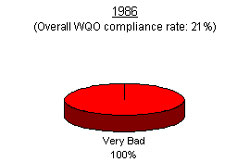
rivers, such that in 1986 WQO compliance for the area barely
registered at 21%, and the nine river stations monitored in that year
all had WQI grades of ‘Very Bad’. Subsequently, a number of measures
to improve water quality were initiated in the 1980s.
 |
|
 |
|
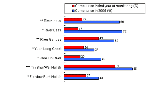
| Compliance with the Water Quality Objectives in the major rivers of North District and Yuen Long in the 1980s and in 2005 |
|
|
 |
 |
*
first monitored in 1986 ** first monitored in 1987
*** first monitored in 1993 |
 |
 |
|
 |
|
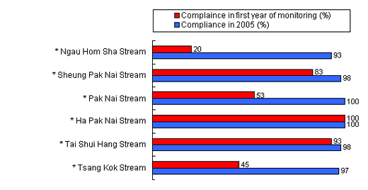
| Compliance with the Water Quality Objectives in the minor streams of Lau Fau Shan in the 1980s and in 2005 |
|
|
 |
 |
*
first monitored in 1989 |
 |
The rivers of the
Northwestern New Territories benefited greatly from the introduction
of the Livestock Waste Control Scheme in June 1988, which banned
livestock farming in new towns and urban areas and required livestock
farms outside those areas to treat their waste to a certain standard
before discharge. The provision of an ex-gratia allowance for farmers
who ceased farming activities helped reduce the number of livestock
farms in the area significantly, while a free waste collection service
brought down the pollution load from those that remained. From 1988
and into the 1990s, major improvements in water quality were recorded.
The declaration of the Deep Bay Water Control
Zone on 1 December 1990 also allowed the EPD to begin enforcing the
Water Pollution Control Ordinance for the area. It mounted a campaign
for industrial and commercial premises and unsewered villages to treat
the waste water they generated.
 |
|
 |
|
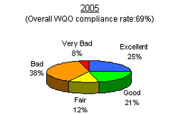
| Water Quality Index gradings for rivers in the Northwestern New Territories,
1986 and 2005 |
|
|
  |
 |
|
 |
Despite the work done over the past two decades
to improve river water quality in this area, there remains room for
further improvement. The six minor streams have been transformed, with
WQO compliance from 93% to 100% in 2005, and WQI grades of 83%
‘Excellent’ and 17% ‘Good’. The seven major rivers, however, have been
slower to improve. WQO compliance in 2005 was still only between 37%
and 85% which, though it marks an improvement over the 1980s, falls
short of what is needed. The WQI was graded ‘Bad’ or ‘Very Bad’ for
56% of the monitoring stations in 2005.
One of the reasons for the persistence of
pollution in these rivers is that hundreds of livestock farms still
remain across this area, and there are also more than 100 unsewered
villages housing large populations. It should be borne in mind too
that improvements in this area are relative. Although there have been
significant leaps forward, the fact is that all these rivers were
extremely polluted in the 1980s, some of them with greater than 100
mg/L BOD5 and 10,000,000 cfu/100 mL E. coli (comparable to raw
sewage!). That means that even where more than 90% of the pollution
load has been removed, what remains is still high compared with rivers
in other parts of Hong Kong.
Most parts of the Northwestern New Territories
remain Livestock Waste Control Areas, meaning that livestock farming
is still allowed. At the end of 2005 there remained hundreds of such
farms across the area, and the sheer numbers doubtless have
contributed to poor river water quality. Although discharge standards
have been imposed at these farms, pollution easily arises when large
numbers of farms discharge their effluent into rivers or streams with
relatively small flows. In addition, some farmers still illegally
discharge their effluent into nearby rivers. Enforcement remains an
uphill battle given the difficult terrain in the New Territories, the
large number of farms, and the complex (and sometimes concealed)
networks of drains that lead to the waterways. The EPD remains very
active in tracking pollution and responding to pollution incidents in
the area.
As mentioned earlier, most parts of the
Northwestern New Territories do not yet have access to the public
sewer, so most domestic sewage is treated only by septic tanks, which
may not always function optimally. As the public sewerage network is
extended across the area over the next decade, water quality should
see further improvements.
Case study: The River Indus and the River Beas
The Rivers Indus and Beas provide good case studies that show both the
advances that have been made since the 1980s, and the problems that
remain to be overcome. The River Indus is one of the largest river
systems in the New Territories, with a total catchment area (including
that of the River Beas and other tributaries) of around 65 square
kilometres. Its main stream flows westward through Man Uk Pin, Kwan
Tei and Sheung Shui, until it joins the Shenzhen River at Lo Wu.
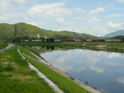 |
The River Indus, with reinforced banks |
|
The River Beas, though a
tributary of the River Indus, is also a major river in its own right.
Its catchment area covers 15 square kilometers, and it flows northward
from Lin Tong Mei through Hang Tau Tai Po and Kwu Tung to join the
River Indus at Ho Sheung Heung.
In the 1980s, there were thousands of livestock
farms scattered around the catchment areas of these two rivers. All
six monitoring stations for the rivers were graded ‘Very Bad’, and
overall WQO compliance for the River Indus was just 21%. The River
Beas, meanwhile, was even worse with just a 19% WQO compliance rate.
Once the Livestock Waste Control Scheme was
introduced in phases from 1988, however, the number of livestock farms
in the region of the Rivers Indus and Beas dropped dramatically. The
Scheme required farms in the River Indus catchment to comply with a
set of effluent standards by 1997, and those in the River Beas
catchment to meet the same standards by 1999. As a result, the
majority of farmers opted to stop farming and instead receive
Government compensation. By 2005, there remained just 12 licensed
livestock farms in the River Indus catchment, and 18 in the River Beas
catchment. All of these farms were required to provide treatment to
their waste.
 |
|
 |
|
Biochemical Oxygen Demand (BOD5)
in the River Beas (RB3) |
|
|
|
 |
|
 |
Evidence of the improvements brought about by
the control of livestock waste can be seen in the accompanying chart,
which shows a significant reduction in BOD in the 1990s as recorded by
one of the River Beas monitoring stations (RB3). By 2005, the River
Indus had achieved 69% compliance with the WQO, and its two upstream
stations were graded ‘Good’. The WQO compliance level of the River
Beas, meanwhile, stood at 72% in 2005, with the station furthest
upstream graded as ‘Good’.
Downstream, however, things still have some way
to go. The station of the River Indus furthest downstream was graded
‘Bad’ in 2005, the two downstream stations of the River Beas only
managed ‘Fair’ gradings, and E. coli levels remained high at
320,000 cfu / 100 mL. This indicates that livestock waste was not the
only major problem facing the rivers. The other was, and remains, the
thousands of unsewered village houses in the two catchments. Even
those with septic tanks were often polluters, when the tanks were
badly designed or poorly-maintained. Further improvements will be made
when the Government extends its public sewers to these villages over
the next decade, as provided for under the North District Sewerage
Master Plan and its review.
Minor streams in Lau Fan Shan
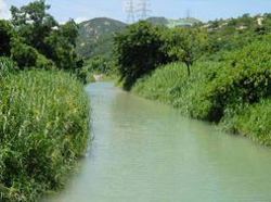 |
Tai Shui Hang Stream has maintained ‘Excellent’ water quality over the past decade |
|
The EPD has monitored six
minor streams in Lau Fau Shan since 1989. They are Ngau Hom Sha
Stream, Sheung Pak Nai Stream, Pak Nai Stream, Tsang Kok Stream, Tai
Shui Hang Stream and Ha Pak Nai Stream. The first four of these were
polluted by livestock waste from farms in the area in the 1980s, and
water quality was graded between ‘Fair’ and ‘Very Bad’ in the period.
Following the implementation of the Livestock Waste Control Scheme,
the streams improved significantly. In 2005, all six streams had WQI
grades of either ‘Good’ or ‘Excellent’, and enjoyed WQO compliance of
between 93% and 100%.
Other major rivers in North District and Yuen Long
The other major rivers in these areas are Yuen Long Creek, the Kam Tin
River, the River Ganges, Tin Shui Wai Nullah and Fairview Park Nullah.
All of them suffered similar problems to the Rivers Indus and Beas
discussed in the ‘Case Study’ above. Yuen Long Creek and the Kam Tin
River were the first to be monitored, in 1986, when their WQO
compliance rates were assessed as 24% and 20% respectively. All six
monitoring stations were graded ‘Very Bad’.
In 1987, the River Ganges began to be
monitored, when its WQO compliance rate was recorded as 43%. Two of
its three monitoring stations were graded ‘Very Bad’, although the
third station, situated upstream of the numerous livestock farms, was
graded ‘Excellent’.
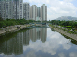 |
Tin Shui Wai Nullah,
running alongside housing estates
|
|
Monitoring of Tin Shui Wai Nullah and Fairview
Park Nullah followed in 1993. In that year, their WQO compliance rates
were 63% and 27% respectively, while the WQI gradings at the
individual monitoring stations ranged from ‘Fair’ to ‘Very Bad’.
These rivers have not shown such positive gains
over the past two decades as those achieved by the Rivers Indus and
Beas. The pollution load of the rivers has certainly been
significantly reduced as a result of the Livestock Waste Control
Scheme and implementation of WPCO controls after December 1990.
However, large numbers of farms remain in the catchments of the River
Ganges, Yuen Long Creek, the Kam Tin River and Tin Shui Wai Nullah.
Unsewered village houses continue to add to the problem.
The Fairview Park Nullah was graded ‘Bad’ in
2005, mainly because its catchment area has been reduced after water
from Ngau Tam Mei began to be diverted into the Kam Tin River in 2002.
After the diversion, the nullah no longer received discharges from
livestock farms, but the diversion did lead to significantly reduced
flow, lowering the nullah’s ability to dilute or disperse pollutants.
For these five rivers, WQO compliance rates
ranged from 37% to 85% in 2005. Overall, 75% of the monitoring
stations were graded as ‘Bad’ or ‘Very Bad’. More than two thirds of
the monitoring stations had E. coli levels of above 100,000 cfu
/ 100 mL. These figures are far from satisfactory, and work remains to
be done in the area.
Future actions
Two major Government initiatives are expected to help improve river
water quality in the Northwestern New Territories over the coming few
years. One is the extension of the sewerage network under the Sewerage
Master Plans drawn up for North District, Yuen Long and Kam Tin, which
are being implemented in phases. Some of the existing sewerage
facilities in the Northwestern New Territories are being upgraded, and
public sewers will be provided for 72 unsewered villages in North
District and 44 in Yuen Long and Kam Tin over the next decade. More
details on the schedules for implementing the sewerage projects for
the area can be found in the tables below.
 |
|
 |
|
| Schedule for implementing village sewerage projects under the North District Sewerage Master Plan and its Review |
|
|
Sewerage Projects |
Status (Schedule) |
Capacity
(in terms of population) |
Coverage |
Expansion and Upgrading of Shek Wu Hui Sewage Treatment Work |
Completed
(1997 – 2001) |
280,000 |
Shek Wu Hui Sewage Treatment Work |
Further Expansion and Upgrading of Shek Wu Hui Sewage Treatment Work |
In progress
(2005 – 2009) |
320,000 |
Shek Wu Hui Sewage Treatment Work |
Western Trunk Sewer |
Completed
(1999 – 2002) |
27,000 |
West of Sheung Shui |
Eastern Trunk Sewer |
Completed
(2002 – 2006) |
25,000 |
East of Sheung Shui |
Southern Trunk Sewer |
Planned for
completion by 2012 |
6,500 |
South of Sheung Shui |
Local treatment plants to serve local communities |
Planned for
completion by 2014 |
7,800 |
Remote villages in scattered areas not covered by the trunk sewers in North District |
Village sewerage to 72 villages |
In progress
(2002 – 2015) |
57,000 |
Villages near to the three Trunk Sewers |
|
 |
|
 |
 |
|
 |
|
| Schedule for implementing village sewerage projects under the Yuen Long & Kam Tin Sewerage Master Plan and its Review |
|
|
Sewerage Projects |
Status (Schedule) |
Capacity
(in terms of population) |
Coverage |
Area 13 & 14 Trunk Sewer |
Completed |
42,000 |
South of Yuen Long town and North of Yuen Long Highway |
Yuen Long South Trunk Sewer |
Completed |
12,000 |
South of Yuen Long Highway |
Kam Tin Trunk Sewerage Phase I |
In progress
(2005 – 2009) |
86,000 |
Au Tau, Pat Heung, Sha Po and Nam Sang Wai areas |
Kam Tin Trunk Sewerage Phase 2 |
Planned for
comletion by 2012 |
68,000 |
Eastern and southern part of Kam Tin |
Expansion of Ha Tsuen Sewage Pumping Station and San Wai Sewage Treatment Work |
Planned for
comletion by 2012 |
- |
Ha Tsuen Sewage Pumping Station and San Wai Sewage Treatment Work |
Yuen Long Effluent Pipeline |
Planned for
comletion by 2012 |
- |
Yuen Long Sewage Treatment Work |
Lau Fau Shan / Mong Tseng Trunk Sewerage |
Planned for
comletion by 2012 |
15,000 |
Lau Fau Shan and Mong Tseng |
Ngau Tam Mei / San Tin Trunk Sewerage |
Planned for
comletion by 2012 |
55,000 |
Ngau Tam Mei and San Tin |
Yuen Long South Branch Sewers |
Planned for
comletion by 2012 |
32,000 |
South of Yuen Long Highway |
Upgrade of San Wai Sewage Treatment Works |
Planned for
comletion by 2014 |
- |
San Wai Sewage Treatment Works |
Village sewerage to 44 villages |
Planned for
comletion by 2013 |
21,000 |
Villages in Yuen Long and Ha Tsuen |
|
 |
|
 |
To reduce public health risks
and improve environmental hygiene in the New Territories, the
Government introduced the Voluntary Surrender of Poultry and Pig Farm
Licence Schemes in 2005 and 2006 respectively. These provide
incentives for livestock farmers to give up their farming licences,
for which they will receive financial compensation. Poultry farms
which join the scheme must close down their farming activities by
February 2007, and pig farms by late 2007. River water quality in the
area is expected to improve further as more livestock farms close
down. |