9A
Baseline
Marine Ecological Resources
This Annex
presents the findings of ecological studies for the proposed wind farm
development areas off
9A.1.1
Ecological
Study Area
The Study Area for the ecological
assessment covers a large area of open water of southern
9A.2
Legislative Requirements and Evaluation Criteria
9A.2.1
Introduction
This
section summarizes all legislative requirements and evaluation criteria for the
protection of species and habitats of marine ecological importance in the Study
Area.
9A.2.2
Legislative
Requirements and Evaluation Criteria
Legislative
requirements and evaluation criteria relevant to the study are as follows:
1.
Marine Parks Ordinance (Cap 476);
2.
Wild Animals Protection Ordinance (Cap
170);
3.
Protection of Endangered Species of
Animals and Plants Ordinance (Cap 586);
4.
Town Planning Ordinance (Cap 131);
5.
6.
The Technical Memorandum on Environmental
Impact Assessment Process under the Environmental Impact Assessment Ordinance
(EIAOTM);
7.
United Nations Convention on Biodiversity
(1992);
8.
Convention on Wetlands of International
Importance Especially as Waterfowl Habitat (the Ramseur Convention);
9.
PRC Regulations and Guidelines; and,
10.
9A.2.3
Marine
Parks Ordinance (Cap 476)
The
Marine Parks Ordinance provides for
the designation, control and management of marine parks and marine
reserves. It also stipulates the
Director of Agriculture, Fisheries and Conservation as the Country and Marine
Parks Authority, which is advised by the Country and Marine Parks Board. The Marine
Parks and Marine Reserves Regulation was enacted in July 1996 to provide
for the prohibition and control certain activities in marine parks or marine
reserves.
9A.2.4
Wild
Animals Protection Ordinance (Cap 170)
Under
the Wild Animals Protection Ordinance,
designated wild animals are protected from being hunted, whilst their nests and
eggs are protected from destruction and removal. All birds and most mammals including all
cetaceans are protected under this Ordinance, as well as certain reptiles
(including all sea turtles), amphibians and invertebrates. The Second Schedule of the Ordinance that
lists all the animals protected was last revised in June 1997.
9A.2.5
Protection
of Endangered Species of Animals and Plants Ordinance (Cap 586)
The
Protection of Endangered Species of
Animals and Plants Ordinance was enacted to align
9A.2.6
Town
Planning Ordinance (Cap 131)
The
Town Planning Ordinance provides for
the designation of areas such as “Coastal Protection Areas”, “Sites of Special
Scientific Interest (SSSIs)”, “Green Belt” and
"Conservation Area” to promote conservation or protection or protect
significant habitat.
9A.2.7
Chapter 10 of the HKPSG
covers planning considerations relevant to conservation. This chapter details the principles of
conservation, the conservation of natural landscape and habitats, historic
buildings, archaeological sites and other antiquities. It also addresses the issue of enforcement. The appendices list the legislation and administrative
controls for conservation, other conservation-related measures in
9A.2.8
Technical
Memorandum on Environmental Impact Assessment Process under the Environmental
Impact Assessment Ordinance
Annex 16 of the EIAOTM sets out the general approach and methodology for assessment
of ecological impacts arising from a project or proposal, to allow a complete
and objective identification, prediction and evaluation of the potential
ecological impacts. Annex 8 recommends the criteria that can be used for evaluating
ecological impacts.
9A.2.9
Other
Relevant Legislation
The
Peoples’ Republic of China (PRC) is a Contracting Party to the United Nations Convention on Biological
Diversity of 1992. The Convention
requires signatories to make active efforts to protect and manage their
biodiversity resources. The Government
of the Hong Kong Special Administrative Region (HKSAR) has stated that it will
be “committed to meeting the environmental objectives” of the Convention ([1]).
The
PRC in 1988 ratified the Wild Animal
Protection Law of the PRC, which lays down basic principles for protecting
wild animals. The Law prohibits killing
of protected animals, controls hunting, and protects the habitats of wild
animals, both protected and non-protected.
The Law also provides for the creation of lists of animals protected at
the state level, under Class I and Class II.
There are 96 animal taxa in Class I and 161 in
Class II. Class I provides a higher
level of protection for animals considered to be more threatened.
9A.3
Marine Ecological Resources – Background
9A.3.1
Introduction
This section describes the baseline conditions of the
marine ecological resources at the Study Area from existing information in
available literature. Baseline
conditions have been assessed based on a review of the findings of relevant
studies and the collation of available information regarding the marine
ecological resources of this part of
Based on this review, an evaluation of the information
collected was conducted to identify any gaps that need to be filled and to
conduct an assessment of ecological importance of the marine habitats. Where information gaps were identified or
where certain habitats or species were considered to warrant further attention,
focussed field surveys have been conducted (see Section 9A.4).
9A.3.2
Site
History
The site for the proposed wind farm is located in the
waters between
In terms of hydrography,
the Study Area is located within a zone of transition in which, in the wet
season, surface waters of reduced salinity, higher temperature and higher
dissolved oxygen occur over the cooler, more saline oceanic waters with lower
dissolved oxygen. In the dry season,
with a reduced flow from the Pearl River adjacent to western Hong Kong waters,
vertical stratification is usually not observed ([2]).
9A.3.3
Literature
Review
A literature review was conducted to determine the
existing marine ecological conditions within the Study Area to identify habitat
resources and species of potential importance.
Based on the literature review the following habitats
and/or organisms of ecological interest have been identified in the Study Area:
·
Hard
Bottom Habitats
-
Intertidal Hard Bottom Habitats
-
Subtidal
Hard Bottom Habitats
·
Soft
Bottom Habitats
-
Intertidal Soft Bottom Habitats
-
Subtidal
Soft Bottom Habitats
·
Epifaunal Assemblages
·
Infaunal Assemblages
·
Marine
Mammals
·
Sea
Turtles
Existing conditions of each of the above marine
resources based on available literature are discussed in more detail in the
following sections.
9A.3.4
Hard
Bottom Habitats
Intertidal Hard Bottom Habitats
Intertidal hard shores of
The intertidal hard bottom habitat of southwestern
There is little published information describing the
intertidal assemblages of the artificial seawall at the Lamma
Power Station Extension. A wet season
intertidal survey was, however, conducted on the west coast of the Lamma Island adjacent to the power station as part of the
environmental impact assessment for the navigation channel and jetty
modification works at the Lamma Power Station ([3]).
Results of this survey indicated that the survey areas were regarded as
of low ecological value and comprised low abundances of common grazing molluscs
and filter feeders with no particular conservation value.
In contrast, focussed quantitative surveys have been
conducted on the natural rocky shores along the west of Lamma
Island during the wet season of 1998 for the Lamma
Power Station Extension EIA ([4]). A
total of 18 to 29 species of intertidal fauna, including grazing molluscs,
common dogwhelks and barnacles (the most abundant
species being the limpet Patelloida saccharina,
the chiton Acanthopleura japonica
and the barnacle Balanus amphitrite),
and some 4 to 8 species macroalgae, were recorded in
the survey transects. The assemblages
recorded were considered to represent common and widespread species typical of
natural rocky shores in
For this EIA Study, it was considered appropriate to
conduct intertidal surveys at the artificial seawall of the Lamma
Power Station Extension in order to fill data gaps and provide up-to-date data
on the ecological value of this habitat.
No surveys were considered necessary on the intertidal habitats in
vicinity of the proposed submarine cable alignment as habitats are relatively distant.
Subtidal Hard Bottom Habitats
Coral communities are commonly regarded as the most
ecologically important and valuable subtidal hard
bottom assemblages. The Agriculture,
Fisheries and Conservation Department (AFCD) reported that there are over 80
species of hard corals recorded in
The western and southern waters of
Ecology of the subtidal
hard bottom habitats in the vicinity of the proposed cable landing site has
been reported in two key studies conducted in 1998 and 2000 respectively. In 1998, Remotely Operated Vehicle (ROV)
surveys were conducted at the footprint of the extension reclamation site and
the seawall of the Ash Lagoon as part of the EIA for the Lamma
Power Station Extension ([6]).
Findings of the surveys showed that there was an abundant assemblage of
soft corals and gorgonians, particularly the sea whip Euplexaura robusta and the soft corals Dendronephthya
spp., localised within a 1 km length at a distance of approximately 50 – 100 m
to the south and the west of the seawall of the Ash Lagoon. The densities of the soft coral assemblages
at the site surveyed (< 0.815 m-2) were, however, considered as
low in comparison with those found at other sites in
A baseline marine ecological monitoring, which
included quantitative Rapid Ecological Assessment (REA) dive surveys, was
conducted in 2000 prior to the commencement of the reclamation works for the Lamma Power Station Extension to establish the status of
the subtidal coral assemblages of the project site ([7]).
Results of the monitoring showed that a total of 11 to 12 species of
corals, predominantly gorgonians and soft corals, were found at the Ash Lagoon
seawall and the seabed about 10 – 20 m from the seawall. As with the 1998 survey, the subtidal assemblages of these sites consisted mainly of
gorgonians and soft corals, with Euplexaura sp. being particularly abundant. The octocoral
abundance at these sites ranged from 4.6 to 10.1 colonies m-2. Isolated colonies of the non-reef building
hard coral species Tubastrea
sp. were also present at the Ash Lagoon Seawall.
A number of studies have been conducted for the subtidal hard bottom habitats along the natural shores in
the vicinity of the proposed cable alignment.
In the 1998 study, ROV and quantitative SCUBA dive surveys were
conducted along the west coast of Lamma Island from Shek Kok Tsui
to Hai Mei Tsui South ([8]).
Findings from the ROV survey at a depth range of 5-10 m indicated that
while the seabed characteristics varied from flat sand to a steep rocky seabed
comprised largely of boulders, the subtidal
assemblages of the sites surveyed were dominated by gorgonians and soft corals
(from the genus Dendronephthya)
with only one hard coral species (Tubastrea sp.) recorded.
Results of subsequent quantitative SCUBA survey at shallower coastal
region of the same sites revealed that these sites were generally covered by
rocks and sand with shell debris and coral cover was very low (mean cover <
1.4 % of the transect). Coral diversity
was also very low, comprising hard corals from the family Faviidae
and Psammocora superficialis,
and the soft corals Dendronephthya
spp. The subtidal
assemblages were dominated by sessile organisms such as mussels Septifer virgatus and Perna viridis and
barnacle Balanus
spp., and mobile fauna including gastropods, crabs, sea cucumber and
urchins. Overall, the ROV and SCUBA
surveys concluded that the relative abundance and diversity of corals recorded
at the sites surveyed was low in comparison with other areas in
Another dive survey was conducted in 2001 which
revisited half of the sites surveyed in the 1998 survey ([9]).
Similar findings were reported on the seabed conditions and low
abundance of hard corals and octocorals, with two
additional hard coral genera Cyphastrea and Goniastrea recorded.
As part of a study of the marine habitats of
Dive surveys conducted around Yung Shue Wan, which is about 1 km away from the proposed cable
landing point, concluded that the identified coral community was not of great
significance in comparison to other areas in Lamma ([11]).
For this EIA Study, it was considered appropriate to
conduct subtidal dive surveys at the artificial
seawall of the Lamma Power Station Extension and at
hard substrate(s) along the cable alignment in order to fill data gaps and
provide up-to-date data on the ecological value of this habitat type.
9A.3.5
Soft
Bottom Habitats
Intertidal Soft Bottom Habitats
Sandy shores along the west coast of Lamma Island that faces the wind farm site include the
sandy shore adjacent to the Lamma Power Station, Kat
Tsai Wan, Tit Sha Long and two gazetted beaches at
Hung Shing Yeh and Lo So Shing, which are at least 1.5 km from the cable landing
point at the Lamma Power Station Extension.
There are no intertidal soft habitats within 500 m of
the cable landing point, and as such, they are not considered further here and
in the Impact Assessment.
Subtidal Soft Bottom Habitats
Epifauna
Subtidal soft bottom habitats, as well as supporting infaunal species, commonly support macro-benthic epifauna. These
organisms are generally > 1 mm in size and live either on or within the
surface sediments. Due to the nature of
the Hong Kong’s fishery and the typical subtidal
substratum in Hong Kong being soft bottom (sandy or silty)
habitat, data on subtidal epifaunal
assemblages in Hong Kong are primarily available from studies on benthic
fisheries resources, collected by demersal trawling
surveys.
Information on the epifaunal
assemblages of the Study Area have been taken from the AFCD-commissioned study
on Fisheries Resources and Fishing Operations in Hong Kong ([13]).
Trawl surveys undertaken as part of AFCD’s
study indicated that that the highest biomasses recorded in the waters were
contributed by Squillidae (mantis shrimp) for both
south (waters outside Shek Kok
Tsui) and north (waters outside Yuen Kok) Lamma Island, which is over
2 km away from the Project Site. Other
families such as Synodontidae (lizard fish) and Dasyatidae (stingrays) have been recorded in south Lamma and north Lamma,
respectively.
Two species of horseshoe crab, Tachypleus tridentatus and Carcinoscorpius rotundicauda,
have previously been recorded in AFCD surveys around Hong Kong waters (AFCD
2006) ([14]), including the mudflat of Shui Hau as the key nursery
grounds for T. tridentatus
([15]).
The horseshoe crab nursery ground at Shui Hau is located far away from the proposed Wind Farm Site
and cable route (at least 10 km), and is considered to be too remote to be
affected by the Project works.
No surveys were considered necessary for epifaunal assemblages as a review of the available
literature provided sufficient evidence of a low ecological value habitat in
the waters surrounding the proposed wind farm and along the submarine cable
route off
Infauna
Subtidal infauna are organisms (>
0.5 mm in size) living either on or within the surface sediments of the
seabed. In order to provide an
indication of the potential ecological value of the infaunal
assemblages at the wind farm site and cable route in the context of seabed of
Hong Kong waters, it is considered useful to review studies that have
investigated infaunal assemblages in
A number of studies have been carried out
in the vicinity of the wind farm site and cable route, dating back to 1982 and
mostly in the 1990s ([16])
([17])
([18])
([19])
([20])
([21]).
In summary, these studies suggest that infaunal
assemblages are polychaete-dominated, with mean
abundance and mean biomass generally lower than the overall mean values (101.4 individuals m-2and 35.2 g m-2
respectively) for
Table 9A.1 Biomass
of Infaunal Assemblages from the
|
Study |
Area/ Date |
Biomass (g m-2) |
|
Shin & Thompson 1992 |
West Lamma Channel |
20.20 |
|
Hong Kong Mean |
35.20 |
|
|
APH Consultants 1994 |
APH-13 December 1993 |
14.68 |
|
APH-13 June 1994 |
3.93 |
|
|
APH-15 December 1993 |
13.13 |
|
|
APH-15 June 1994 |
7.53 |
|
|
AXIS Consultants 1994 |
Navigation Channel September 1994 |
22.20 |
|
Mouchel 1998 |
S15 ( |
24.14 |
|
ERM 1996 – 1997 Seabed Ecology Studies |
|
7.50 |
|
|
6.10 |
|
|
East of Ninepins (August) |
12.80 |
|
|
|
35.70 |
|
|
South Cheung Chau
(November) |
47.20 |
|
|
Eastern Waters (April) |
32.90 |
|
|
Tathong Channel (April) |
35.70 |
|
|
|
30.60 |
|
|
ERM 1998 |
Power Station Reclamation Site (September) |
6.00 |
Territory-wide surveys of Hong Kong subtidal infauna assemblages were
conducted at proposed wind farm location and in the vicinity of the proposed
cable corridor in 2001([23]).
Nine sampling stations (Station Nos. 35 – 39, 55 – 57) are close to the
proposed area of works and data extracted from them are considered to provide
representative, up-to-date information of the assemblages within the Study
Area. Findings of the surveys indicated
that the substratum of the nine sampling stations is covered by very fine sand
(average median diameter of 5.83 phi unit).
Benthic assemblages found were typical of
Table 9A.2 Summary
Information from Grab Survey in 2001 ([24])
|
Proposed Project Area |
Station No. |
Summer (Wet Season) |
Winter (Dry Season) |
||||
|
No. of Sp. |
Abundance |
Biomass |
No. of Sp. |
Abundance |
Biomass |
||
|
Cable route |
38 |
43 |
322 |
18.84 |
56 |
692 |
19.12 |
|
|
39 |
39 |
284 |
54.70 |
34 |
142 |
81.20 |
|
Mean |
41 |
303 |
36.77 |
45 |
417 |
50.16 |
|
|
Wind farm |
35 |
34 |
330 |
8.70 |
39 |
264 |
6.82 |
|
|
36 |
43 |
416 |
61.76 |
34 |
262 |
42.58 |
|
|
37 |
42 |
330 |
13.20 |
41 |
288 |
11.14 |
|
Mean |
40 |
359 |
27.89 |
38 |
271 |
20.18 |
|
|
Overall mean |
40 |
331 |
32.33 |
42 |
344 |
35.17 |
|
|
Overall in HK |
33 |
540 |
71.20 |
34 |
450 |
28.00 |
|
Based on the above, the infaunal
assemblages in the proposed Study Area are not considered to have great
abundance, diversity and biomass in comparison to other areas of
9A.3.6
The general marine and coastal waters off south Lamma Island have been proposed for designation as Marine
Parks as a result of the AFCD-commissioned feasibility study ([25]).
The proposed park is approximately 1 km away the wind farm development
site. The proposed designation primarily
aims to protect one of the core habitats for finless porpoise and the nesting
site in
9A.3.7
Other
Protected Areas
The Cape D’Aguilar Marine
Reserve, the potential
9A.3.8
Marine
Mammals
A total of 16 (and possibly up to 18) species of
marine mammals (mostly cetaceans) have been recorded in
A long-term monitoring programme on humpback dolphins
and finless porpoise in Hong Kong and adjacent waters has been undertaken since
1995 to provide broad knowledge on the distribution, abundance, habitat use,
and life history of these species ([30])
([31])
([32])
([33])
([34])
([35]).
Systematic databases established from this programme have been evaluated
to form the basis of this review.
Indo-Pacific Humpback Dolphin
The Indo-Pacific humpback dolphin Sousa chinensis
is a tropical/ sub-tropical cetacean widely distributed in the coastal and
inshore waters of the Indian and western Pacific oceans ([36]).
It is protected locally by the Wild
Animals Protection Ordinance (Cap. 170), and is listed as "Near
Threatened" in the 2009 IUCN Red List of Threatened Species ([37]). Sousa chinensis
is also listed in CITES Appendix I (i.e. highest protection), and is listed as
“Endangered” in the China Species Red List and a "Grade I National Key
Protected Species" in
It has been reported that in 2006 at least 1,200 ([38])
individual dolphins were
estimated to utilise the waters of the Pearl River Estuary and
Abundance of humpback dolphins in
The long-term monitoring study in the past 13+ years
has shown that humpback dolphins do not regularly occur in eastern waters with
higher salinity, as this species has a strong preference for waters with
influence from the Pearl River freshwater input ([47])
([48]).
Waters to the east of Lantau are rarely used
by dolphins, and this area appears to comprise the eastern boundary of their
range ([49]). The long-term sightings database has revealed
that there have only been four sightings of humpback dolphins in the eastern
survey areas (i.e. including southwestern Lamma waters) since 2000
(Figure 9A.3). Of
note, all of these were solitary animals and were sighted only in winter months
(in Jan 2000, Feb 2004, and Nov and Dec 2007) ([50]).
Their occurrence in these waters was thus considered to be extralimital.
Quantitative grid analysis (i.e. numbers of sightings
standardised with survey effort) has been established to examine dolphin
abundance and their fine-scale habitat usage.
Of the areas surveyed, standardised dolphin sighting densities and
dolphin densities were the highest at
On the basis of the review of long-term monitoring
database and relevant literature, southwestern Lamma waters are not considered to be an important area for
Indo-Pacific humpback dolphins.
Finless Porpoise
The finless porpoise Neophocaena phocaenoides is a tropical/ sub-tropical
cetacean widely distributed in coastal marine waters, as well as some river
mouths and estuaries, from the Persian Gulf eastwards around the rim of the
Indian Ocean to the Taiwan Strait area in southern Japan. It is protected locally by the Wild Animals Protection Ordinance (Cap. 170),
and is listed as "Vulnerable" in the 2009 IUCN Red List of Threatened
Species ([52]). Neophocaena phocaenoides
is also listed in CITES Appendix I (i.e. highest protection), and is listed as
“Endangered” in the China Species Red List.
As such N. phocaenoides
is considered a species of conservation interest/ concern, both locally in Hong
Kong and regionally in
In Hong Kong, finless porpoise occur year-round, and
they can be found primarily in the southern (i.e Po Toi, Lamma, Southeast and
Southwest Lantau) and eastern (i.e.
The majority of porpoise sightings have been made in
southern waters, with a high concentration of sightings near the Po Toi Islands, at the southwest corner of Lamma
Island, in southeast Lantau (southern waters of
Cheung Chau and southwest corner of Chi Ma Wan
Peninsula) and southwest Lantau (near Shek Kwu Chau
and the Soko Islands) (Figure 9A.5). These areas are thus considered to be the
main habitats for finless porpoises in
Seasonal variation in distribution is evident for
finless porpoises in
Quantitative grid analysis on porpoise
habitat use revealed that during 2004-08, standardised porpoise sighting
densities (i.e Sightings Per Survey Effort (SPSE)
values, representing the number of on-effort sightings per km2, with
the survey area mapped using a 1 km by 1 km grid) were higher at the waters
just south of Soko Islands, the offshore waters in
Southeast Lantau, at southwest corner of Shek Kwu Chau
and Cheung Chau, near Stanley Peninsula and around Po
Toi Islands than in other areas of Hong Kong waters ([69]).
Therefore based on the results of the information
available from the long-term sighting data on marine mammals in the waters of
9A.3.9
Sea
Turtles
Of the seven extant species of sea turtles,
loggerheads (Caretta caretta),
leatherbacks (Dermochelys coriacea), hawksbills (Eretmochelys
imbricata), olive ridleys
(Lepidochelys olivacea)
and greens (Chelonia mydas)
have been reported to occur in the waters of Hong Kong ([70]).
However, the green turtle is the only species confirmed to nest in
Green turtle Chelonia mydas is protected locally by the Wild Animals Protection Ordinance (Cap. 170), and is listed as
"Endangered" in the 2009 IUCN Red List of Threatened Species ([72]).
It is also listed in CITES Appendix I (i.e. highest protection), and is
listed as “Critically Endangered” on the China Species Red List and a
"Grade II National Key Protected Species" in
The major nesting site for green turtles in Hong Kong
is at Sham Wan, southern Lamma Island, which is over
5 km from the proposed wind farm site ([73]) ([74]) ([75])
([76]). A
small number of green turtles are known to nest at Sham Wan, although nesting
does not occur every year ([77]).
In 1999, the 0.5 ha of sandy beach at Sham Wan was listed as a Site of
Special Scientific Interest and a Restricted Area under the Wild Animals Protection Ordinance (Cap. 170). Access to the beach is prohibited between 1
June and 31 October each year during the green turtle nesting season ([78]).
Satellite tracking of female green turtles nesting at
Sham Wan beach has been undertaken since 2002 to examine their regional
migration patterns. Results of the
tracking showed that the same nesting female (named “Hong Kong 2”) tracked in
June 2003 and August 2008 used the waters close to Sham Wan, in the south and
southeast of
Satellite tracking of on a foraging green turtle in
the Gangkou Sea Turtle National Nature Reserve
populations in China revealed that they moved from its foraging grounds in Daya Bay to Wanshan Archipelago ([80]), migrating past or through Hong Kong, by
Basalt Island, Tung Lung Chau and other parts of Hong
Kong waters, between nesting and foraging grounds (Figure 9A.8). Another tracking study conducted on
post-nesting green turtles populations in Taiwan also indicated that the
turtles often utilise several coastal areas as temporal residential forging
sites as far as to the east coast of China ([81]).
There is no documented evidence of foraging activity
by sea turtles in
Due to the very occasional occurrence of green turtle
in
9A.4
Baseline Marine Ecological
Surveys
The literature review of the marine ecological
habitats and resources of the waters within and in close proximity to the
proposed wind farm and cable route has provided an indication of the ecological
importance of the Project Site. However, in order to provide up-to-date information on
marine ecological baseline conditions, a number of field surveys were
considered necessary and were undertaken in 2008 and 2009 (Table 9A.3).
Table 9A.3 Marine
Ecology Baseline Surveys
|
Survey Type |
Methodology |
Season & Date |
|
Intertidal Assemblages at Lamma
Power Station Extension |
Quantitative surveys of three 100 m belt transects
(at high, mid and low intertidal zones) at artificial seawall, covering both
wet and dry seasons |
Wet Season: 28 Oct 2008 Dry Season: 27 Feb 2009 |
|
Subtidal
Benthic Assemblages |
Quantitative grab sampling surveys at 10 sites
(three stations at each site). Sites
surveyed represented the wind farm site, cable route and reference sites |
Wet Season: 19 Oct 2008 Dry Season: 19 Mar 2009 |
|
Subtidal
Hard Bottom Assemblages (Coral) |
Semi-quantitative (Rapid Ecological Assessment (REA)
technique) and qualitative (recorded within Study Area and areas in the
vicinity) |
4 and 5 May 2009 |
|
Marine Mammal |
Quantitative vessel-based survey using line
transect methods around Qualitative vessel-based survey around |
1 day per month for 6 months, from Dec 2008 to May
2009 (inclusive) (Winter / Spring) in the following dates: 24 Dec 2008 (Winter), 16 Jan 2009 (Winter), 13 Feb
2009 (Winter), 13 Mar 2009 (Spring), 15 Apr 2009 (Spring) and 11 May 2009
(Spring 3 days per month for 5 months, from July to October
2008 (Summer / Autumn), and in June 2009 (Summer), in the following dates: 24, 26, 28 July 2008 (Summer), 15, 21, 25 August 2008 (Summer), 4, 11, 26 September 2008 (Summer), 6, 17, 20 October 2008 (Autumn), and 10, 11, 17
June 2009 (Summer) |
Survey methodologies have been selected to
follow standard and accepted techniques for marine ecological surveys. In addition, each methodology has been previously
conducted as part of other Environmental Impact Assessments (EIA) studies,
accepted under the Hong Kong Environmental Protection Department Environmental Impact Assessment Ordinance
(EIAO).
Survey schedules have been undertaken in accordance
with the Environmental Impact Assessment
Ordinance, Cap.499 Guidance Note 7/2002 - Ecological Baseline Survey for
Ecological Assessment, specifically in terms of the following:
·
Duration
of Survey;
·
Seasonality;
·
Types
of Survey Period; and
·
Survey
Effort.
The following sections present the
methodology and results for each marine ecological survey undertaken as part of
the assessment of marine ecological baseline conditions.
9A.4.1
Intertidal
Hard Bottom Assemblages
Survey Methodology
Only one type of intertidal habitat, artificial
shore, was identified in the vicinity of the proposed cable landing point The artificial
shore at the Lamma Power Station Extension consists
of steep seawall of large boulders, and this habitat was examined for the
intertidal surveys.
The intertidal surveys consisted of quantitative
transect surveys at three locations (T1, T2 and T3, Figure 9A.9)
along the artificial sloping seawall within the 500 m study boundary of the
proposed landing point. Intertidal
surveys were conducted in both the wet and dry seasons. Local tide tables were used to assess tidal
height at the site and times of surveys.
At each of the three survey locations, three 100 m
horizontal (belt) transects along the seawall were surveyed at each of the
three shore heights: 2 m (high-shore), 1.5 m (mid-shore) and 1 m (low-shore)
above Chart Datum (CD). On each
transect, ten quadrats (50 cm × 50 cm) were placed
randomly to assess the abundance and diversity of flora and fauna. All organisms found in each quadrat were identified and recorded to the lowest possible
taxonomic level to allow density per quadrat to be
calculated. Sessile species, such as
algae (encrusting, foliose and filamentous), barnacles and oysters, in each quadrat were also identified and estimated as percentage
cover on the rock surface using a double-strung, 50 cm × 50 cm quadrat.
Survey Results
Wet Season Survey Results
A total of 18 faunal groups were recorded
in the wet season survey. At all three
transect locations, dominant (in terms of abundance) organisms recorded
included the littorinid snail Echinolittorina spp. in the
high-shore, the topshell Monodonta labio and the limpet Cellana toreuma in the mid-shore, and the limpets
C. toreuma
and Patelloida saccharina
and the common dogwhelk Thais clavigera in the low-shore. Sessile species including the barnacle Tetraclita squamosa and
the oyster Saccostrea cucullata are
also present in the low-shore. Both the
abundance/ density of mobile species and percentage cover of sessile species
were considered to be low (mean ~ 38 individuals m-2 and ~ 13 % m-2
respectively). Only four species of
algae and one species of cyanobacteria were recorded
in the wet season survey, and the percentage cover by these species was very
low (mean < 4 % m-2). The
surveys results are summarised below:
|
Wet Season |
Mean Abundance per m2 |
||
|
Species |
High-shore |
Mid-shore |
Low-shore |
|
Gastropods (individuals) |
|
|
|
|
Acanthopleura japonica |
0.27 |
0.93 |
3.47 |
|
Cellana toreuma |
0.00 |
12.40 |
17.20 |
|
Chlorostoma argyrostoma |
0.00 |
0.00 |
0.27 |
|
Echinolittorina radiata/ vidua |
8.13 |
0.13 |
0.00 |
|
Echinolittorina trochoides |
0.40 |
0.00 |
0.00 |
|
Monodonta labio |
2.53 |
13.33 |
12.13 |
|
Nerita yoldii |
0.00 |
1.07 |
4.00 |
|
Patelloida pygmaea |
0.00 |
0.00 |
0.40 |
|
Patelloida saccharina |
3.20 |
5.60 |
13.60 |
|
Siphonaria japonica |
0.13 |
0.27 |
0.53 |
|
Thais clavigera |
0.00 |
5.33 |
9.73 |
|
Grapsus albolineatus |
0.00 |
0.00 |
0.40 |
|
Crustaceans |
|
|
|
|
Isopod sp. (individuals) |
0.00 |
0.00 |
0.80 |
|
Ligia exotica (individuals) |
1.60 |
0.67 |
1.60 |
|
Capitulum mitella (%) |
0.47 |
1.47 |
0.07 |
|
Tetraclita squamosa (%) |
0.87 |
7.83 |
13.87 |
|
Tubeworms |
|
|
|
|
Hydroides sp. |
0.00 |
0.00 |
0.40 |
|
Bivalves |
|
|
|
|
Saccostrea cucullata (%) |
0.27 |
1.13 |
12.73 |
|
Algae (%) |
|
|
|
|
Ralfsia expansa |
0 |
0.67 |
0 |
|
Hildenbrandia sp. |
0 |
2.33 |
3.00 |
|
Corallina sp. |
0 |
0 |
3.27 |
|
Pseudulvella applanata |
0 |
0 |
1.00 |
|
Cyanobacteria (%) |
|
|
|
|
Kyrtuthrix maculans |
0 |
0.83 |
0 |
Dry Season Survey Results
The species composition of the intertidal organisms
during the dry season was similar to that of the wet season, with a total of 17
faunal groups, four algal species and one species of cyanobacteria. Seasonal variation in intertidal assemblage
pattern was attributed to higher abundance of grazing molluscs, particularly Echinolittorina
spp., Cellana toreuma, Monodonta labio, Patelloida saccharina
and Siphonaria japonica, lower abundance of Thais clavigera,
lower percentage cover of Tetraclita squamosa and Saccostrea cucullata, and higher percentage cover of the
encrusting algae Hildenbrandia sp., in the dry than the wet
season. Mean abundance of mobile
species, sessile species and algae recorded in the dry season survey were 64
individuals m-2, 3 % m-2 ~ 21 % m-2 and
respectively. The surveys results are
summarised below:
|
Wet Season |
Mean Abundance per m2 |
||
|
Species |
High-shore |
Mid-shore |
Low-shore |
|
Gastropods
(individuals) |
|
|
|
|
Acanthopleura japonica |
0 |
3.33 |
2.27 |
|
Cellana toreuma |
0.53 |
22.00 |
29.87 |
|
Chlorostoma argyrostoma |
0 |
0 |
0.40 |
|
Echinolittorina radiata/ vidua |
32.00 |
0 |
0 |
|
Echinolittorina trochoides |
1.73 |
0 |
0 |
|
Monodonta labio |
0 |
19.20 |
19.07 |
|
Nerita yoldii |
0 |
0.93 |
1.07 |
|
Patelloida pygmaea |
2.67 |
2.40 |
1.33 |
|
Patelloida saccharina |
1.20 |
12.27 |
19.73 |
|
Siphonaria japonica |
0.93 |
2.53 |
8.00 |
|
Siphonaria laciniosa |
0.13 |
1.07 |
1.73 |
|
Thais clavigera |
0.13 |
2.27 |
1.87 |
|
Crustaceans |
|
|
|
|
Ligia exotica (individuals) |
0 |
0.13 |
0.13 |
|
Capitulum mitella (%) |
0.17 |
1.07 |
0 |
|
Tetraclita squamosa (%) |
0.03 |
1.63 |
0 |
|
Bivalves |
|
|
|
|
Saccostrea cucullata (%) |
0 |
6.23 |
1.10 |
|
Septifer virgatus (%) |
0 |
0.03 |
0 |
|
Algae (%) |
|
|
|
|
Ralfsia expansa |
0 |
0.07 |
0 |
|
Hildenbrandia sp. |
0 |
19.07 |
32.77 |
|
Green algae |
0 |
0 |
0.27 |
|
Encrusting coralline
algae |
0 |
0.33 |
8.83 |
|
Cyanobacteria (%) |
|
|
|
|
Kyrtuthrix maculans |
0.47 |
0.50 |
0 |
Overall, results of the seasonal intertidal surveys
indicated that the artificial sloping seawall of the Study Area exhibited a low
diversity of species. The species
recorded during the surveys are all very common and widespread species on
artificial shores of
9A.4.2
Subtidal Soft Bottom Assemblages – Benthos
Survey Methodology
Sampling Locations
Benthic sediment samples were collected from 10 sites
representative of the subtidal soft-bottom habitats
of the potential wind farm site, cable route and the Study Area. The sampling sites were as follows:
·
Proposed
Wind Farm Location: S1 to S5;
·
Proposed
Transmission Cable Alignment: SP1 and SP2; and
·
Reference
Stations: SR1 to SR3.
The locations of each survey site are shown in Figure 9A.10.
The numbers of sampling stations within the wind farm
and along the cable route were considered sufficient given the relatively
homogeneous nature of sediments at the sites.
The reference stations have been identified in order to provide
information on benthic ecology in areas that may be deemed more sensitive (eg close to Sham Wan of Lamma
Island).
Field Sampling Methodology
At each of the 10 survey sites, three
stations approximately 50 m apart were established and one grab sample was
collected from each station. Stations
were sampled using a modified Van Veen grab sampler
(960 cm2 sampling area; 11,000 cm3 capacity) with a
supporting frame attached to a swivelling hydraulic winch cable.
Sediments from the grab samples were
sieved on board the survey vessel. The
sediments were washed onto a sieve stack (comprising 1 mm2 and 500 m2
meshes) and gently rinsed with seawater to remove all fine material. Following rinsing any material remaining on
the two screens was combined and carefully rinsed using a minimal volume of
seawater into pre-labelled thick triple-bagged ziplock
plastic bags. A 5% solution of
borax-buffered formalin containing Rose Bengal in seawater was then added to
the bag to ensure tissue preservation.
Samples were sealed in plastic containers for transfer to the taxonomy
laboratory for sorting and identification.
Laboratory Techniques
The benthic laboratory performed sample
re-screening after the samples had been held in formalin for a minimum of 24
hours to ensure adequate fixation of the organisms. Individual samples from the 500 m2
and 1 mm2 mesh sieves were gently rinsed with fresh water into a 250
m2
sieve to remove the formalin from the sediments. Sieves were partially filled while rinsing a
specific sample to maximize washing efficiency and prevent loss of
material. All material retained on the
sieve was placed in a labelled plastic jar, covered with 70% ethanol, and
lightly agitated to ensure complete mixing of the alcohol with the
sediments. Original labels were retained
with the re-screened sample material.
Standard and accepted techniques were used for
sorting organisms from the sediments.
Small fractions of a sample were placed in a petri
dish under a 10-power magnification dissecting microscope and scanned
systematically with all animals and fragments removed using forceps. Each petri dish was
sorted at least twice to ensure removal of all animals. Organisms representing major taxonomic
groups, such as Polychaeta, Arthropoda,
Mollusca, and miscellaneous taxa,
were sorted into separate, labelled vials containing 70% ethanol.
Taxonomic identifications were performed by
qualified and experienced specialist using stereo dissecting and high-power compound microscopes. These were generally to the species level
except for unidentified taxa, which were identified
to genera as far as practical. The careful
sampling procedure employed minimizes fragmentation of organisms. If breakage of soft-bodied organisms
occurred, only anterior portions of fragments were counted, although all
fragments were retained and weighed for biomass determinations (wet weight).
Survey Results
Survey Dates and Conditions
Grab samples were collected from all 10 sampling
sites in both the dry (19 March 2009) and wet (28 October 2008) seasons. In general, conditions during surveys were fine
with relatively calm sampling conditions throughout.
Dry Season Survey Results
A total of 173 individual organisms were collected
from the 30 grab sampling stations at the 10 survey sites during the dry season
survey in March 2009. The specimens belong
to eight Phyla with a total of 10 classes, 41 families and 49 species
identified. Table 9A.4 provides a summary on the abundance, biomass and
taxonomic richness of infauna collected at each site. A complete set of raw data is presented in Tables 1 & 2 of Annex 9A1.
Results of the dry season benthic survey showed that infaunal abundance, biomass and taxonomic richness (here
represented by number of families and species of infaunal
organisms) were very low at all sampling sites (Table 9A.4). There was some
variation in infaunal abundance, biomass and
taxonomic richness among sampling sites.
Whilst the mean infaunal abundance and mean
taxonomic richness per station were significantly higher at the Reference Site
SR1 than other sites, infaunal biomass was
significantly higher at the wind farm site S3 than other sites (Table 9A.4). With the exceptions explained above, all
sampling sites showed relatively similar infaunal
abundance, biomass and taxonomic richness.
Variation within site (ie among sampling stations)
was also considered to be small, as can be seen from the low standard deviation
(SD) values (Table 9A.4).
In terms of infaunal
abundance, the majority (71.7%) of organisms recorded were from the Phylum Annelida, followed by Arthropoda
(12.1%) and Sipuncula (5.2%). Each of the other recorded phyla contributed
to < 3 % of the number of individuals recorded. The polychaete worm
Prionospio queenslandica,
from the family Spionidae, was the most abundant
species from the dry season survey (total abundance = 25 individuals),
particularly at SR1 (total abundance = 16 individuals). No rare or uncommon species were recorded in
the survey. The composition of infaunal assemblage at each site in terms of mean numerical
abundance of organisms present (grouped by class) in the dry season survey is
presented in Figure 9A.11.
In terms of infaunal
biomass, organisms from the Phylum Mollusca
contributed 41% of the total biomass recorded, while organisms from Chordata, Arthropoda and Annelida also contributed significant biomasses (25.3%,
22.4% and 10.2% respectively). Each of
the other recorded phyla contributed to < 5 % of the total infaunal biomass recorded.
High biomass of molluscs was contributed by a single individual of the
bivalve Scapharca
sp. at one sampling station of the S3 site.
The composition of infaunal assemblage at each
site in terms of mean biomass of organisms present (grouped by class) in the
dry season survey is presented in Figure 9A.12.
Table 9A.4 Composition
of Infaunal Assemblages at the Sampling Sites for the
Soft Bottom Habitat Surveys at the
|
Location |
Site |
Number of Stations Sampled |
Total Number of Infaunal Individuals |
Mean Number of Individuals per Station (± SD) |
Mean Number of Individuals per m2 (± SD) |
Total Biomass (g wet weight) |
Mean Taxonomic Richness (No. Families) per Station (± SD) |
Mean Taxonomic Richness (No. Species) per Station (± SD) |
Mean Biomass per Individual (g wet weight) |
||||
|
Reference |
SR1 |
3 |
45 |
15.00 |
(± 6.00) |
156.25 |
(± 62.50) |
2.1081 |
8.33 |
(± 2.31) |
8.67 |
(± 2.08) |
0.0468 |
|
|
SR2 |
3 |
16 |
5.33 |
(± 1.53) |
55.56 |
(± 15.91) |
3.3299 |
4.67 |
(± 1.53) |
4.67 |
(± 1.53) |
0.2081 |
|
|
SR3 |
3 |
9 |
3.00 |
(± 1.00) |
31.25 |
(± 10.42) |
1.5615 |
2.00 |
(± 1.00) |
2.00 |
(± 1.00) |
0.1735 |
|
Wind farm |
S1 |
3 |
19 |
6.33 |
(± 1.15) |
65.97 |
(± 12.03) |
0.4430 |
5.33 |
(± 0.58) |
5.33 |
(± 0.58) |
0.0233 |
|
|
S2 |
3 |
13 |
4.33 |
(± 1.53) |
45.14 |
(± 15.91) |
0.8796 |
3.67 |
(± 1.15) |
4.00 |
(± 1.73) |
0.0677 |
|
|
S3 |
3 |
14 |
4.67 |
(± 2.08) |
48.61 |
(± 21.68) |
9.2311 |
4.33 |
(± 2.52) |
4.33 |
(± 2.52) |
0.6594 |
|
|
S4 |
3 |
10 |
3.33 |
(± 0.58) |
34.72 |
(± 6.01) |
0.6409 |
3.33 |
(± 0.58) |
3.33 |
(± 0.58) |
0.0641 |
|
|
S5 |
3 |
10 |
3.33 |
(± 2.52) |
34.72 |
(± 26.21) |
6.1169 |
3.00 |
(± 2.00) |
3.00 |
(± 2.00) |
0.6117 |
|
Cable |
SP1 |
3 |
14 |
4.67 |
(± 2.52) |
48.61 |
(± 26.21) |
1.3030 |
4.67 |
(± 2.52) |
4.67 |
(±2.52) |
0.0931 |
|
|
SP2 |
3 |
23 |
7.67 |
(± 5.51) |
79.86 |
(± 57.37) |
0.2853 |
4.33 |
(± 2.08) |
4.33 |
(± 2.08) |
0.0124 |
Wet Season Survey Results
A total of 194 individual organisms were collected
from the 30 grab sampling stations at the 10 survey sites during the wet season
survey in October 2008. The specimens
belong to eight Phyla with a total of 10 classes, 34 families and 43 species
identified. Table 9A.5 provides a summary on the abundance, biomass and
taxonomic richness of infauna collected at each
site. A complete set of raw data is
presented in Tables 3 & 4 of Annex 9A1.
Results of the wet season 2008 benthic survey showed
that, as with the results of the dry season survey, infaunal
abundance, biomass and taxonomic richness were very low at all sampling sites (Table 9A.5). Whilst the mean infaunal
abundance and mean taxonomic richness per station were similar across sampling
sites, with SP2 showing a slightly higher infaunal
abundance, infaunal biomass was significantly higher
at the wind farm site S2 than other sites (Table
9A.5). Variation within site (ie among sampling stations) was also considered to be
small, as can be seen from the low standard deviation (SD) values (Table 9A.5).
Table 9A.5 Composition
of Infaunal Assemblages at the Sampling Sites for the
Soft Bottom Habitat Surveys at the
|
Location |
Site |
Number of Stations Sampled |
Total Number of Infaunal Individuals |
Mean Number of Individuals per Station (± SD) |
Mean Number of Individuals per m2 (± SD) |
Total Biomass (g wet weight) |
Mean Taxonomic Richness (No. Families) per Station (± SD) |
Mean Taxonomic Richness (No. Species) per Station (± SD) |
Mean Biomass per Individual (g wet weight) |
||||
|
Reference |
SR1 |
3 |
17 |
5.67 |
(±
2.52) |
59.03 |
(±
26.21) |
1.1714 |
4.00 |
(±
1.00) |
4.33 |
(±
1.15) |
0.0689 |
|
|
SR2 |
3 |
11 |
3.67 |
(±
2.52) |
38.19 |
(±
26.21) |
2.3300 |
3.00 |
(±
1.73) |
3.00 |
(±
1.73) |
0.2118 |
|
|
SR3 |
3 |
21 |
7.00 |
(±
2.65) |
72.92 |
(±
27.56) |
1.4495 |
5.67 |
(±
2.08) |
5.67 |
(±
2.08) |
0.0690 |
|
Wind farm |
S1 |
3 |
19 |
6.33 |
(±
0.58) |
65.97 |
(±
6.01) |
2.1422 |
4.67 |
(±
1.15) |
5.00 |
(±
1.00) |
0.1127 |
|
|
S2 |
3 |
21 |
7.00 |
(±
0.00) |
72.92 |
(±
0.00) |
12.2189 |
5.67 |
(±
0.58) |
5.67 |
(±
0.58) |
0.5819 |
|
|
S3 |
3 |
22 |
7.33 |
(±
3.06) |
76.39 |
(±
31.82) |
2.5986 |
5.00 |
(±
1.00) |
5.33 |
(±
1.53) |
0.1181 |
|
|
S4 |
3 |
20 |
6.67 |
(±
1.53) |
69.44 |
(±
15.91) |
1.5394 |
5.33 |
(±
1.53) |
5.33 |
(±
1.53) |
0.0770 |
|
|
S5 |
3 |
12 |
4.00 |
(±
2.00) |
41.67 |
(±
20.83) |
0.3607 |
3.33 |
(±
1.15) |
3.33 |
(±
1.15) |
0.0301 |
|
Cable |
SP1 |
3 |
22 |
7.33 |
(±
0.58) |
76.39 |
(±
6.01) |
1.9954 |
4.00 |
(±
1.00) |
5.00 |
(±
1.00) |
0.0907 |
|
|
SP2 |
3 |
29 |
9.67 |
(±
6.43) |
100.69 |
(±
66.97) |
1.7443 |
6.00 |
(±
1.00) |
6.33 |
(±
1.53) |
0.0601 |
In terms of infaunal
abundance, the majority (67.0%) of organisms recorded in the wet season were
from the Phylum Annelida, followed by Arthropoda (12.4%) and Nemertinea
(5.2%). Each of the other recorded phyla
contributed to < 5 % of the number of individuals recorded. The polychaete worm
Aglaophamus dibranchis,
from the family Nephtyidae, was the most abundant
species from the wet season survey (total abundance = 35 individuals), and it
was present in most of the sampling sites.
No rare or uncommon species were recorded in the wet season survey. The composition of infaunal
assemblage at each site in terms of mean numerical abundance of organisms
present (grouped by class) in the wet season survey is presented in Figure 9A.11.
In terms of infaunal
biomass, organisms from the Phylum Echinodermata
contributed 42% of the total biomass recorded, while organisms from Arthropoda, Chordata and Annelida also contributed significant biomasses (19.4%,
16.6% and 10.8% respectively). Each of
the other recorded phyla contributed to < 6 % of the total infaunal biomass recorded.
High biomass of echinoderms was contributed by a single individual of
the sea cucumber Actinopyga echinites at
one sampling station of the S2 site. The
composition of infaunal assemblage at each site in
terms of mean biomass of organisms present (grouped by class) in the wet season
survey is presented in Figure 9A.12.
Overall, results from the dry and wet season surveys
undertaken as part of this EIA suggested that infaunal
assemblages of the surveyed sites consisted of common and widespread species
typical of disturbed environment, i.e. numerical dominance of low biomass,
stress-tolerant and short-lived polychaete
species. Infaunal
assemblage structure was largely similar between seasons, with slightly higher infaunal abundance, biomass and taxonomic richness in the
wet than the dry season. The abundance,
biomass and taxonomic richness of infauna at and in
the vicinity of the wind farm site and cable route off Southwest Lamma are very low in comparison with the average values
reported by CityU Professional Services Limited
(2002) for benthic assemblages in Hong Kong (34 species per 0.5 m2,
450 individuals per m2 and 28 g per m2).
9A.4.3
Subtidal Hard Bottom Habitat – Coral
Methodology
Subtidal dive surveys were undertaken at subtidal
hard bottom habitats within and in close proximity to the footprint of the
Project Area with a key focus at the proposed cable landing site and along the
cable route where hard substrata were noted from the geophysical survey
undertaken for this site (see Section 12). The dive surveys comprised the following two
components:
·
Qualitative
spot dive survey; and
·
Semi-quantitative
Rapid Ecological Assessment (REA) survey.
Each of these surveys is described further in the
following sections. Survey locations are
presented in Figure 9A.13 and details of
the surveys are summarised in Table 9A.6.
Table 9A.6 Survey
Transects and Type of Survey Undertaken
|
Survey Site |
Type of Survey |
Total Length of Area Surveyed |
|
T1 |
Semi-quantitative
REA survey |
100 m |
|
T2 |
Semi-quantitative
REA survey |
100 m |
|
T3 |
Semi-quantitative
REA survey |
100 m |
|
T4 |
Semi-quantitative
REA survey |
100 m |
|
T5 |
Semi-quantitative
REA survey |
100 m |
|
T6 |
Semi-quantitative
REA survey |
100 m |
|
T7 |
Semi-quantitative
REA survey |
100 m |
|
T8 |
Semi-quantitative
REA survey |
100 m |
|
Patch 4 |
Qualitative
spot dive survey |
5 m |
|
Patch 6 |
Qualitative
spot dive survey |
5 m |
|
Patch 7 |
Qualitative
spot dive survey |
5 m |
|
Patch 8 |
Qualitative
spot dive survey |
5 m |
|
Patch 9 |
Qualitative spot
dive survey |
5 m |
|
Patch 10 |
Qualitative
spot dive survey |
5 m |
Qualitative Spot Dive Survey
Recent geophysical surveys identified a number of
small patches of hard substrate along the cable route. These patches, identified as superficial
dumped materials, occurred within the 150 m wide cable corridor and within
approximately 10 m depth or less. Whilst
the age of the patches is unknown, it
was noted that some of the materials were located on top of trawl lines, which
suggested that these could be introduced on to the seabed relatively
recently. The materials were also
thought to be relatively mobile as displacement of the materials by trawling
activity was seen on geophysical images (Figure 9A.14).
A series of targeted spot dive checks were carried
out at selected patches of dumped materials along the proposed cable route to
investigate if coral communities are present at these potential areas of hard
substrate (Figure 9A.13).
Not all identified patches of dumped material were surveyed, but the
hard substrate patches surveyed are thought to be representative of all patches
of dumped material noted in the Study Area.
Representative ground-truthing of sessile
assemblages at the selected hard substrate patches was thus used to
characterise the biological nature of all patches of dumped material
identified.
At each survey site, a spot dive reconnaissance check
was conducted by qualified coral specialists by SCUBA to confirm the substrate
type and associated sessile benthos, particularly the presence of coral
communities (hard and soft corals). The
immediate seabed area around the patch (5 m radius around the centre point) was
checked, and representative photographs of the seabed and associated fauna were
taken. Coral species encountered during
the spot dive checks were identified to the lowest possible taxonomic level.
Rapid Ecological Assessment (REA) Survey Method
The Rapid Ecological Assessment (REA) technique was
employed in order to investigate the presence of any coral communities (hard
and soft corals) associated with subtidal hard bottom
habitats at the cable landing point area at the Lamma
Power Station Extension. The REA
technique allows semi-quantitative information on the ecological attributes of
the subtidal habitat to be obtained in a relatively
simple way without compromising scientific rigour. This technique is the standard practices for
EIA marine baseline surveys in Hong Kong and has been modified from the
standardised REA survey technique established for the assessment of coral
communities on the Great Barrier Reef ([85])
for marine environment of
Hong Kong ([86]).
A series of REA surveys were conducted by qualified
coral ecologists by SCUBA at a total of eight transects along the seawall of
the Lamma Power Station Extension (Table 9A.6; Figure 9A.13). The spatial coverage of the proposed REA
transects included the zone of potential direct and indirect impacts, which
encompassed the seawall at and in the vicinity of the proposed cable landing
point. These REA transects represented a
100 m stretch of seawall at two depth zones:
·
Shallow
depth zone: -2 to -5 mCD (typically the depth range
of coral colonies associated with seawall habitat); and
·
Deep
depth zone: -6 to -10 mCD.
The depths of these transects might be adjusted
slightly based on the substrate habitats, the presence or absence of hard and
soft corals, and field conditions.
Field data of the REA survey were recorded by coral
specialists who are experienced in the underwater identification of sessile
benthic taxa.
REA surveys were carried out using 100 m long transects with the
transect tapes laid out within a single ecological zone - habitat - depth range
as bulleted above.
Following the laying of the transect line, the field
surveyors swam along the transect slowly and conducted
a REA of the seabed. The REA methodology encompassed an assessment of the
benthic cover (Tier I) and taxon abundance (Tier II)
undertaken in a swathe ~ 4 m wide, 2 m either side of each transect. The belt transect width was dependent on
underwater visibility and might be adjusted to a swathe ~2 m wide, 1 m either
side of the each transect in case of reduced visibility. An explanation of the two assessment
categories (Tiers) used in the survey is presented below.
Tier I -
Categorisation of Benthic Cover
Upon the completion of each survey transect, five
ecological and seven substratum attributes were assigned to one of seven
standard ranked (ordinal) categories (Tables
9A.7 and 9A.8).
Table 9A.7 Categories used in the REA Surveys -
Benthic Attributes
|
Ecological |
Substratum |
|
Hard coral |
Hard substrate |
|
Dead standing coral |
Continuous pavement |
|
Soft coral |
Bedrock |
|
Black coral |
Rubble |
|
Macroalgae |
Sand |
|
Turf algae |
Silt |
|
|
Large boulders (>50 cm) Small boulders (<50 cm) |
|
|
Rocks (<26 cm) |
Table 9A.8 Categories used in the REA Surveys -
Ordinal Ranks of Percentage Cover
|
Rank |
Percentage Cover (%) |
|
0 |
None recorded |
|
1 |
1-5 |
|
2 |
6-10 |
|
3 |
11-30 |
|
4 |
31-50 |
|
5 |
51-75 |
|
6 |
76-100 |
Tier II -
Taxonomic Inventories to Define Types of Benthic Communities
An inventory of benthic taxa
was compiled for each transect. Taxa were identified in
situ to the following levels:
·
Scleractinian (hard) corals to species wherever possible;
·
Soft
corals, anemones and conspicuous macroalgae recorded
according to morphological features and to genus level where possible; and
·
Other
benthos (including sponges, zoanthids, ascidians and
bryozoans) recorded to genus level wherever possible but more typically tophylum plus growth form.
Following the completion of each transect survey,
each taxon in the inventory was ranked in terms of abundance
in the community (see Table 9A.9). These broad categories rank taxa in terms of relative abundance of individuals, rather
than the contribution to benthic cover along each transect. The ranks are subjective assessments of
abundance, rather than quantitative counts of each taxon.
Table 9A.9 Ordinal Ranks of Taxon
Abundance
|
Rank |
Abundance |
|
0 |
Absent |
|
1 |
Rare (a) |
|
2 |
Uncommon |
|
3 |
Common |
|
4 |
Abundant |
|
5 |
Dominant |
|
Note: (a)
The
classification of “rare” abundance refers to low abundance (small quantity)
on the transect, rather than in terms of
distribution in |
|
A set of environmental site descriptors
was recorded for each REA transect as follows:
(A)
The degree of exposure to prevailing wave energy was ranked from 1
- 4, where:
1 = sheltered (highly protected by topographic features from
prevailing waves);
2 = semi-sheltered (moderately protected);
3 = semi-exposed (only partly protected); and
4 = exposed (experiences the full force of prevailing wave energy).
(B)
Sediment deposition on the reef substratum (particle sizes ranging
from very fine to moderately coarse) rated on a four point scale, from 0 – 3,
where:
0 = no sediment;
1 = minor (thin layer) sediment deposition;
2 = moderate sediment deposition (thick layer), but substrate can be
cleaned by fanning off the sediment; and
3 = major sediment deposition (thick, deep layer), and substrate
cannot be cleaned by fanning.
A suite of representative photographs was taken for
each REA transect. All field data were
checked upon completion of each REA transect and a dive survey proforma sheet was completed at the end of the fieldwork
day. Photographs compiled for each REA
transect were then reviewed and REA data verified. Verified REA data were presented in terms of:
·
Site
(transect) information (Tier I and II data), depth and environmental
descriptors; and
·
Species
abundance data for each transect.
Species lists, species richness and mean values for
ecological and substratum types were compiled.
The rank abundance values were converted to a mid-value percentage
cover.
Survey Results
The dive surveys were conducted on 4 and 5 May
2009. The conditions during surveys were
fine with calm conditions throughout.
The visibility was generally < 1.0 m.
Results of Qualitative Spot Dive Checks
Results of qualitative dive surveys at Patches 4, 6,
7, 8, 9 and 10 confirmed that the seabed at these locations was composed of
sandy silts with sparse rock and rubble.
The hard substrate at Patches 4, 6 and 8 were sparsely colonised with
the gorgonians Echinomuricea
sp. and Menella sp., and substrate at Patch 8 showed
sparse colonization of soft coral Dendronephthya sp., Echinomuricea sp. and black coral Cirripathes sp. (Table 9A.10). The seabed at Patches 7, 9 and 10 showed no
colonization of sessile taxa. The communities identified during the survey
were located on the hard substrate, but these areas only formed a small
percentage of the seabed as the majority of the seabed comprised soft
substrate. Figure
9A.15 presents some images taken at the qualitative dive survey
locations.
Table
9A.10 Coral
Species Recorded at the Qualitative Spot-Check Patches
|
|
Patch 4 |
Patch 6 |
Patch 7 |
Patch 8 |
Patch 9 |
Patch 10 |
|
|
|
|
|
|
|
|
|
Octocoral
Species (a) |
|
|
|
|
|
|
|
Dendronephthya
sp. |
0 |
0 |
0 |
1 |
0 |
0 |
|
Echinomuricea sp. |
1 |
1 |
0 |
1 |
0 |
0 |
|
Menella
sp. |
1 |
1 |
0 |
1 |
0 |
0 |
|
|
|
|
|
|
|
|
|
Black Coral Species |
0 |
0 |
0 |
1 |
0 |
0 |
|
|
|
|
|
|
|
|
Note: (a).
0=absent, 1=present
Results of REA Survey
Along each transect the seabed composition was
identified and conditions were noted as shown in Table 9A.11 and Table 9A.12. The substrate of the REA transects was mainly
large boulders. Some images taken at the
REA dive survey transects are presented in Figure 9A.16.
Octocoral species were not recorded in any of the REA
transects at the Lamma Power Station Extension
seawall. Although this was contrary to
the findings of the 2000 baseline marine ecological monitoring at the Ash
Lagoon Seawall, this is not unusual as localised environmental conditions (e.g.
current velocity and turbidity) at the sites may potentially affect the
distribution and abundance of octocorals.
Hard coral coverage at the REA transects was very low
(< 5 %), and hard coral was not recorded at T2 and T8. A total of three hard coral species were
recorded during the REA surveys (Table
9A.13). The scleractinian
coral Oulastrea crispata and ahermatypic cup corals were recorded in the majority of the transects, and a sub-massive Porites sp. was recorded at
T5. These results support the findings
of the 2000 surveys that hard coral abundance and diversity was very low on
artificial seawall of this area.
The predominant species recorded during the REA
survey was Oulastrea crispata. This coral species belongs to the Faviidae family of which all species are known to have high
tolerance limits to sub-optimal physico-chemical
conditions often associated with the Hong Kong nearshore
environment, e.g. fluctuations in salinity and sea surface temperature (daily
and seasonal), elevated sedimentation loading and total suspended sediment, and
reduced light attenuation levels. Oulastrea crispata is a
common and ubiquitous coral species in
Common subtidal species
recorded at the REA transects included the barnacle Balanus sp., the bivalves Tridacna sp. and Perna viridis, the
sea urchin Diadema setosum and
some gastropods.
Overall, results of the dive surveys show that very
sparse colonies of locally common, widespread coral species were present along
the proposed cable route and the cable landing point, and their abundance and
diversity were considered to be very low in the context of subtidal
coral assemblages in
Table 9A.11 Description of the Seabed Recorded along Each
Transect and the Qualitative Surveys
|
Transect (T)/ Patch (P) |
Depth |
Description |
|
T1 |
-3 m CD |
The seabed was
mainly composed of large boulders with sparse small boulders and rocks. A few colonies of encrusting hard coral Oulastrea crispata
were found along the transect. |
|
T2 |
-6 m CD |
The seabed was
mainly composed of large boulders with sparse small boulders. No hermatypic
hard coral colonies were found. Several
ahermatypic cup coral colonies of the Family Dendrophyllidae were recorded. |
|
T3 |
-4 m CD |
The seabed was
mainly composed of large boulders with sparse small boulders. Several colonies of encrusting hard coral Oulastrea crispata
were recorded along the transect. |
|
T4 |
-6 m CD |
The seabed was
mainly composed of large boulders with sparse small boulders. Several colonies of encrusting hard coral Oulastrea crispata
and ahermaptypic cup coral colonies of the Family Dendrophyllidae were recorded along the transect. |
|
T5 |
-4 m CD |
The seabed was
mainly composed of large boulders with sparse small boulders. Several colonies of encrusting hard coral Oulastrea crispata
and sub-massive Porites
sp. were recorded. |
|
T6 |
-6 m CD |
The seabed was
mainly composed of large boulders.
Several Oulastrea crispata
colonies were recorded. Ahermatypic cup corals of the Family Dendrophyllidae
were common along transect. |
|
T7 |
-4 m CD |
The seabed was
mainly composed of large boulders with sparse small boulders and rocks. Colonies of encrusting hard coral Oulastrea crispata
were found along the transect. |
|
T8 |
-7 m CD |
The seabed was
mainly composed of large boulders with sparse large boulders and rocks. Ahermatypic cup
corals of the Family Dendrophyllidae were commonly
found along transect. |
|
P4 |
-10 m CD |
The seabed was
predominately covered by sand and silt with scattered and sparse
rubbles. Few colonies of the
gorgonians Echinomuricea
sp. and Menella sp. were recorded. |
|
P6 |
-12.3 m CD |
The seabed was
composed of sand and silt with scattered and sparse rubbles. Few colonies of the gorgonians Echinomuricea
sp. and Menella sp. were recorded. |
|
P7 |
-12.9 m CD |
The seabed was
mainly composed of silt with sparse rocks and rubble recorded. No sessile organisms were observed. |
|
P8 |
-13 m CD |
The seabed was
composed of sandy substrate with some sparse rocks and rubbles. A number of coral colonies, including the
gorgonians Echinomuricea
sp., Menella
sp., Echinogorgia
sp., soft coral Dendronephthya
sp. and black coral Cirripathes
sp. were recorded. |
|
P9 |
-12 m CD |
The seabed was
composed of silt with no sessile organisms found. |
|
P10 |
-13 m CD |
The seabed was
composed of silt with no sessile organisms found. |
Table 9A.12 Seabed Attributes along the Semi-Quantitative Survey
Transects
|
|
T1 |
T2 |
T3 |
T4 |
T5 |
T6 |
T7 |
T8 |
|
Transect depth (a) |
s |
d |
s |
d |
s |
d |
s |
d |
|
Seabed attributes (b) |
|
|
|
|
|
|
|
|
|
Bedrock |
0 |
0 |
0 |
0 |
0 |
0 |
0 |
0 |
|
Boulders – large |
4 |
6 |
5 |
6 |
6 |
6 |
6 |
6 |
|
Boulders – small |
1 |
1 |
1 |
1 |
1 |
1 |
1 |
1 |
|
Rock |
1 |
1 |
1 |
0 |
1 |
1 |
1 |
0 |
|
Rubble |
1 |
0 |
0 |
0 |
1 |
0 |
1 |
0 |
|
Sand |
1 |
1 |
0 |
0 |
0 |
0 |
0 |
0 |
|
Silt |
0 |
1 |
1 |
1 |
1 |
1 |
1 |
2 |
|
Ecological
attributes (b) |
|
|
|
|
|
|
|
|
|
Hard coral |
1 |
0 |
1 |
1 |
1 |
1 |
1 |
0 |
|
Dead standing coral |
0 |
0 |
0 |
0 |
0 |
0 |
0 |
0 |
|
Soft coral |
0 |
0 |
0 |
0 |
0 |
0 |
0 |
0 |
|
Black coral |
0 |
0 |
0 |
0 |
0 |
0 |
0 |
0 |
|
Turf algae |
1 |
1 |
1 |
1 |
1 |
1 |
1 |
1 |
|
Macroalgae |
0 |
0 |
0 |
0 |
0 |
0 |
0 |
0 |
|
Coralline algae |
3 |
2 |
3 |
1 |
2 |
1 |
2 |
1 |
Notes: (a) T1 to T8 = transect line; s= shallow
water; d=deep water
(b) 1=<5% Cover, 2= 6-10% Cover, 3 =
11-30% Cover, 4 = 31-50% Cover, 5 = 51-75% Cover, 6 = 76-100% Cover.
Table 9A.13 Species Recorded
along the REA Survey Transects
|
Type |
Taxon/
Family |
Species |
T1 |
T2 |
T3 |
T4 |
T5 |
T6 |
T7 |
T8 |
|
Hard Coral |
Hermatypic |
|
|
|
|
|
|
|
|
|
|
|
Faviidae |
Oulastrea
crispata |
2 |
0 |
2 |
2 |
2 |
2 |
2 |
0 |
|
|
Poritidae |
Porites sp. |
0 |
0 |
0 |
0 |
2 |
0 |
0 |
0 |
|
|
Dendrophyllidae |
Unidentified
cup coral sp. |
0 |
2 |
0 |
2 |
0 |
3 |
0 |
3 |
|
Others |
Crustacea |
Balanus
sp. |
3 |
4 |
3 |
3 |
3 |
3 |
3 |
0 |
|
|
|
Crab
(unidentified) |
0 |
0 |
0 |
0 |
0 |
2 |
2 |
0 |
|
|
|
Hermit crab
(unidentified) |
0 |
0 |
3 |
0 |
0 |
0 |
0 |
2 |
|
|
Bryozoa |
Schizoporella
errata |
0 |
0 |
0 |
2 |
0 |
0 |
0 |
2 |
|
|
|
Unidentified
sp. |
2 |
0 |
0 |
0 |
0 |
0 |
0 |
0 |
|
|
Bivalvia |
Tridacna sp. |
3 |
2 |
3 |
2 |
2 |
2 |
0 |
0 |
|
|
|
Perna
viridis |
0 |
2 |
3 |
0 |
2 |
0 |
0 |
2 |
|
|
Gastropoda |
Gastropod (eg Topshell, Whelks) |
2 |
3 |
3 |
0 |
2 |
2 |
3 |
0 |
|
|
|
Cypraea
arabica |
0 |
0 |
2 |
0 |
2 |
0 |
0 |
0 |
|
|
Echinodermata |
Diadema
setosum |
3 |
3 |
4 |
3 |
3 |
3 |
0 |
0 |
|
|
|
Anthocidaris
crassispina |
2 |
0 |
0 |
0 |
0 |
2 |
3 |
0 |
|
|
|
Salmacis
sphaeroides |
2 |
0 |
0 |
0 |
2 |
0 |
2 |
0 |
|
|
Cnidaria |
Haliplanella
lineata |
0 |
0 |
0 |
0 |
2 |
0 |
0 |
0 |
|
|
|
Sea squirt |
0 |
0 |
0 |
0 |
0 |
0 |
2 |
2 |
|
|
Porifera |
Sponges |
0 |
2 |
0 |
2 |
0 |
0 |
0 |
2 |
|
|
Sabellidae |
Fan worm |
0 |
0 |
0 |
0 |
2 |
0 |
2 |
0 |
Note: (a).
0=absent, 1=rare, 2=uncommon, 3=common, 4=abundant, 5=dominant. Also note patches were surveyed by spot dive
so that REA data were not collected for these sites.
The ranks shown in the Table above indicate the
relative abundance of each coral in relation to other corals in the community.
In other words, these broad categories rank taxa in
terms of relative abundance of individuals, rather than the contribution to
benthic cover along each transect. The
ranks are subjective assessments of abundance, rather than quantitative counts
of each taxon. For instance, if a coral is ranked as
‘common’, it means it was more frequent than other coral species along the transect. It
should be borne in mind that coral cover along all of the transects where
corals occurred was very low (<5% cover)
Drop Camera Survey
In addition to the REA and geophysical surveys (see above
subsections), in order to gain
additional information on the seabed conditions within the wind farm site and
along the cable route a drop camera system was deployed to capture images of
the seabed. The drop camera system has
been developed in conjunction with the Australian Institute of Marine Science
(AIMS) and field tested (by ERM staff) in
The remote drop camera system is a portable system
which is deployed and retrieved by hand over the side of a survey vessel. The camera system was deployed to the seabed
by a trained ERM marine scientist, with instructed assistance of vessel crew (Box 9A.1). On reaching the seabed, the camera system was
maintained close to the seabed (<1m) for a suitable length of time, along a
line of boat drift to enable a series of representative photographs of the
seabed to be captured.
|
|

Survey Location
The drop camera system was deployed at six points in
the wind farm site, including areas in vicinity to the five benthic grab
sampling points. In addition, two points
were surveyed along the cable route. The
location of the survey points is shown in Box
9A.2.
Box 9A.2 Drop
Camera Survey Transects
|
|
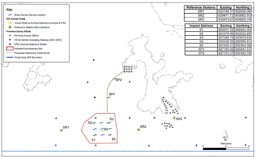
Drop Camera Survey Findings
The drop camera survey was carried out on the 19
March 2009. The conditions during the
survey were fine with calm sampling conditions throughout. The drop camera survey confirmed that at all
survey locations the seabed consisted of silty mud
with no hard substrate recorded. Box 9A.3 provides an indicative image of
the conditions recorded during the drop camera survey.
Box 9A.3 Indicative
Image of the Seabed Conditions at the Wind Farm Site and along the Cable Route
|
|

9A.4.4
Marine Mammals
Vessel-based Survey Methodology
General Approach and Survey Area
A set of systematic standard line-transect vessel
surveys ([89])
on the finless porpoise Neophocaena phocaenoides
was undertaken as part of this EIA to examine the abundance, distribution,
encounter rate and habitat use of this species in the Study Area. Surveys were undertaken within the Lamma Survey Area (Figure 9A.17). Due to the extensive data available through
the AFCD’s long-term marine mammal monitoring
programme, a six month survey programme was undertaken from December 2008 to
May 2009, hence covering winter (December-February) and spring (March-May)([90]).
These new data would then be collated with AFCD long term data to
sufficiently characterise existing and historical marine mammal use of the
waters of the Study Area.
The survey methodology of this study was consistent
and compatible with that adopted in the long-term marine mammal monitoring
programme conducted under the Hong Kong Cetacean Research Project (HKCRP)
funded by AFCD since 1995 to allow potential comparisons and pooling of data
for analysis as part of this EIA.
Survey Methods
Vessel surveys were conducted from one survey vessel
(ca. 12-15 m length), weather permitting (Beaufort 0-6, no heavy rain, and
visibility > 1,200 m). The vessel had
an open upper deck, affording relatively unrestricted visibility. The observer team conducted searches and
observations from the flying bridge area, 4-5 m eye height above the water's
surface. Two experienced observers (a
data recorder and a primary observer) made up the on-effort survey team ([91]).
As the survey vessel transited the transect lines at
a constant speed of about 13-15 km/hour, the primary observer searched for
porpoises continuously through 7 x 35 Brunton marine
binoculars, while the data recorder searched with unaided eyes and filled out
the datasheets. Both observers searched
the sea ahead of the vessel, between 270° and 90° (in relation to the bow, which is defined
as 0°). One to two
additional experienced observers were available on the boat to work in shift
(i.e. rotate every 30 minutes) in order to minimise fatigue of the survey team
members.
Effort data collected during on-effort survey periods
included time and position (latitude and longitude) for the start and end of
search effort, weather conditions (Beaufort sea state and visibility) and
distance travelled in each series (a continuous period of search effort) with
the assistance of a handheld GPS (Garmin Geko
201). When porpoises were sighted, the
survey team would end the survey effort and would be taken as off-effort, and
immediately recorded the initial sighting distance and angle of the porpoise
group from the survey vessel, as well as sighting time and position, on the
sighting datasheet. The research vessel
was then diverted from its course to approach the porpoise group for group size
estimation, assessment of group composition and behavioural observations.
The perpendicular distance (PSD) of the porpoise
group to the transect line was later calculated from the initial sighting distance
and angle. The line-transect data
collected during the present study were compatible with the long-term databases
of HKCRP/ AFCD in a way that it can be analyzed by established computer
programmes (e.g. all recent versions of DISTANCE programme including version
5.0, ArcView© GIS programme) for
examination of population status including trends in abundance, distribution
and habitat use.
Data Analysis Methods
Distribution Analysis:
The line-transect survey data were integrated with Geographic Information
System (GIS) in order to visualize and interpret seasonal and annual
distribution of porpoises within the Lamma Survey
Area during the survey period using sighting positions. Location data of porpoise groups were plotted
on map layers of Hong Kong using a desktop GIS (ArcView©
3.1), and the dataset was also stratified into different subsets to examine
distribution patterns of porpoise groups in different seasons and with
different categories of group sizes. The
data collected as part of this survey were examined in conjunction with the
long-term sighting databases of HKCRP/ AFCD to examine the distribution
patterns of finless porpoises in the Lamma Survey
Area over the past years.
Encounter Rate Analysis:
Since line-transect survey effort was uneven among different survey
areas and across different years, the encounter rates of porpoises (number of
on-effort sightings per 100 km of survey effort) were calculated in each survey
area in relation to the amount of survey effort conducted. The encounter rate could be used as an
indicator to determine area of importance to porpoises among the survey areas.
Quantitative Grid
Analysis of Habitat Use: Positions of on-effort sightings were
retrieved from the wind farm survey database and the long-term porpoise
sighting database, and then plotted onto 1-km2 grids among the three
survey areas (i.e. Sai Kung, Ninepins and Lamma) on GIS.
Sighting densities (number of on-effort sightings per km2)
and porpoise densities (total number of porpoises from on-effort sightings per
km2) were then calculated for each 1-km2 grid with the
aid of GIS. Sighting density grids and
porpoise density grids were then further normalized with the amount of survey
effort conducted within each grid. The
total amount of survey effort spent on each grid was calculated by examining
the survey coverage on each line-transect survey to determine how many times
the grid was surveyed during the study period.
For example, when the survey boat traversed through a specific grid 50
times, 50 units of survey effort were counted for that grid.
With the amount of survey effort calculated for each
grid, the sighting density and porpoise density of each grid were then
normalized by survey effort (i.e. divided by the unit of survey effort). The newly-derived unit for sighting density
was termed SPSE, representing the number of on-effort sightings per
100 units of survey effort. In addition, the derived unit for actual
porpoise density was termed DPSE, representing the number of porpoise per 100 units of survey effort. Plotting the
DPSE values of surveyed grid squares on maps allows areas where the most dense sightings of porpoises occur to be
identified. Among the 1 km2
grids that were partially covered by land, the percentage of sea area was
calculated using GIS tools, and their SPSE and DPSE values were adjusted
accordingly. The following formulae were
used to estimate SPSE and DPSE in each 1 km2 grid within the study
area:
SPSE = ((S / E) x 100) / SA%
DPSE = (D / E) x 100 / SA%
Where;
S = total
number of on-effort sightings
D = total
number of porpoise from on-effort sightings
E = total
number of units of survey effort
SA% = percentage
of sea area
Both SPSE and DPSE values were useful in
examining porpoise usage within a 1-km2 area, and they were
calculated using pooled data from the present study and the past decade of
finless porpoise monitoring (i.e. 1999-2008).
Survey Results
Line-transect Survey Effort and Finless
Porpoise Sightings
In the six-month study period (December
2008 to May 2009), a total of six days of systematic line-transect surveys had
been completed in the Lamma Survey Area, covering a
total of 422.1 km of survey effort.
A total of five groups of finless
porpoises numbering 13 individuals were sighted during the 6-month survey, and
these sightings were all made during on-effort search in the spring season
(March and May 2009). A total of two
porpoise individuals were sighted during off-effort search during the
qualitative surveys conducted in summer and autumn (July to October 2008). Only the five on-effort sightings were used
to examine porpoise encounter rates and habitat use patterns. No Indo-Pacific humpback dolphins were
sighted during the surveys.
Overall Distribution
It is important to recognize that, due to
differential survey effort in various survey areas, it is not possible to
compare densities of porpoises by examining maps of distribution. The distribution maps are only useful for
determining where animals do and do not occur, and for comparing use of the
area on a small scale (within a survey area).
Comparisons of density or habitat use on a larger scale should make use
of numerical density estimates or the results of the grid analyses (discussed
below).
Of the five on-effort sightings of finless
porpoises, three were made near southwest Lamma,
while two was made in the northeast portions of the Lamma
Survey Area near eastern Lamma and Stanley (Figure 9A.18).
The two off-effort porpoise sightings were made in near Stanley.
Porpoise sighting records (both on-effort
and off-effort) from this survey were evaluated in conjunction with those from AFCD’s monitoring survey conducted during the same period (i.e survey effort of one day per month for six months), and
those from AFCD’s long-term marine mammal monitoring
programme from 1996 to 2008, to provide a detailed illustration of finless
porpoise distribution in the Lamma Survey Area. These comparisons showed that porpoises were
sighted sporadically around the southwest and southeast corners of
Seasonal
Distribution
Seasonal variations in finless porpoise
occurrence within the Lamma Survey Area were examined
using data collected from this study and those from AFCD’s
long-term monitoring programme. Overall,
in Lamma waters, finless porpoise occurred more
frequently during winter and spring months (i.e. December to May) than in
summer and autumn months (i.e. June to November) (Figure 9A.21). Whilst porpoise sightings mostly concentrated
at the southwest corner of
As for the proposed wind farm site,
porpoise sightings were the highest in spring and only very few porpoises were
sighted within this area during summer and autumn (Figure 9A.21).
Encounter Rate
Encounter rates of finless porpoise were
calculated as an indicator to determine the relative importance of the Lamma Survey Area to this species.
In the present study, porpoise encounter
rates were calculated using only line-transect survey data collected in
Beaufort 0-2 condition, since the porpoise encounter rate dropped markedly from
3.73 sightings per 100 km of survey effort in Beaufort 0-2 conditions to 0.24
in Beaufort 3-6 conditions during the study period, since even in relatively
calm conditions finless porpoise can be more difficult to find at sea.
The porpoise encounter rate calculated for
the Lamma Survey Area using the wind farm survey data
and AFCD’s porpoise monitoring data for the same
period (December 2008 to May 2009) was 4.7 sightings per 100 km of survey
effort. This was higher than the
encounter rates recorded in Sai Kung and Ninepins in
2008-09 ([92]).
The porpoise encounter rate calculated for the Lamma
Survey Area using the wind farm survey data and AFCD’s
long-term monitoring data (from December 1999 to November 2008) was 3.2
sightings per 100 km of survey effort, which was higher than the overall
encounter rate recorded in previous years of monitoring, as well as the encounter
rates recorded in Ninepins and Sai Kung during the
same study period ([93]).
Porpoise encounter rate within the Lamma
Survey Area was the highest in spring (5.4 per 100 km of survey effort) among
the four seasons.
On the basis of the above, the usage of
waters of Lamma Island by finless porpoises was
considered to be high in comparison to other areas of Hong Kong, especially
during March to May.
Grid Analysis of Habitat Use
Grid analysis of habitat use provides the
best way to compare porpoise use of specific areas, especially on a small
scale. Because the data are standardized
for differential survey effort, it is possible to make direct comparison of
density of two grids for interpretation.
As with the analysis on encounter rate,
only the survey data collected in favourable survey conditions were used for
the analysis. To satisfy this condition,
only the survey data from the days that had at least 50% of total survey effort
collected in Beaufort 2 or below conditions were included in the grid analysis.
Data collected from surveys of this Study
and those from AFCD’s long-term monitoring programme
(December 1999 to November 2008, December through May of each year only) were
used for deriving the SPSE and DPSE values for the 169 grids in the Lamma Survey Area.
On-effort porpoise sightings in Beaufort 2
or below conditions were only made in 53 of the 169 grids since December 1999 (Figure 9A.22).
The average DPSE value of the 169 grids for finless porpoises in the Lamma Survey Area was 13.7 (range = 0 – 133).
Habitat use of porpoises was very uneven
among the 1 km2 grids within the Lamma
Survey Area, and porpoise densities were the highest near the southwest corner
of Lamma Island (e.g. Grids CC30, DD31-32 and CC34) (Figure 9A.22).
However, it should be cautioned that relatively high porpoise densities
as shown in some of the grids (e.g. Grids X35, CC33 [overlap with wind farm
site] and NN33) may represent artefacts of relatively low survey effort in
these grids (i.e. < 10 units of survey effort, hence giving very high
SPSE/DPSE values even with only one porpoise sighting).
Among the nine grids that overlapped with
the proposed wind farm site, porpoises were sighted in all except one grid, and
DPSE values for six of the nine grids were considered as moderate to high (Figure 9A.22).
To correct for potential bias as a result of relatively low survey
effort in three of these nine grids (only 6 – 9 units of survey effort),
average DPSE value of these nine grids was calculated using DPSE values of only
six grids and the adjusted average DPSE value was 48.2. Based on the above, the proposed site appeared
to be moderately, and in some subareas highly, used by finless porpoises.
Likewise, among the four grids that
overlapped with the proposed cable route, porpoises were sighted in only two
grids and their DPSE values were considered as moderate and moderate to high (Figure 9A.22).
The average DPSE value of these four grids was low to moderate (<
35).
Group Size
Porpoises sighted in this study tended to
occur in small groups, with four of the five porpoise groups composed of 1-2
animals and one group with eight animals.
Finless porpoise average group size for this study was 2.6 ± 3.05
porpoise/ group, which was slightly lower than that reported from AFCD’s long-term monitoring programme (December 1999 to
November 2008) for the Lamma Survey Area (3.3
porpoise/ group).
Data from this study were combined with AFCD’s long-term monitoring data (collected since 1996) for
analysis and the results showed that large porpoise groups were frequently
sighted at the southwest corner of Lamma Island near
Ha Mei Tsui (Figure 9A.23). A few large porpoise groups were also sighted
at and near the proposed wind farm site.
9A.5
Evaluation of Ecological Importance of the Study Area
The existing conditions of the marine ecological
habitats and resources in the waters of the proposed wind farm and cable route
have been assessed. These baseline
conditions have been based on available literature and, where considered
necessary, focussed field surveys to update and supplement the data. Based on this information, the ecological
importance of each habitat has been determined according to the EIAO-TM Annex 8 criteria, as follows:
·
Naturalness
·
Size
·
Diversity
·
Rarity
·
Re-creatability
·
Fragmentation
·
Ecological
Linkage
·
Potential
Value
·
Nursery
Ground
·
Age
·
Abundance
It should be pointed that that within the Study Area
of this EIA, which covers quite a large areal extent, variations in the
ecological characteristics of habitats across different locations (which are
kilometres apart) are likely to be present.
To provide information of key relevance to the marine ecological
assessment, the ecological importance of habitats presented in this baseline is
therefore primarily focussed on the vicinity of the works areas of the proposed
project.
9A.5.1
Intertidal
Habitats
The criteria listed below have been applied to the
information gathered or reviewed on the marine ecology of the intertidal habitats
at the Lamma Power Station Extension in order to
determine the ecological value. The
application of these criteria has led to the intertidal artificial seawall at
the Lamma Power Station Extension to be classified as
low ecological importance (Table 9A.14).
Table 9A. 14 Ecological Importance of Intertidal Habitats at the Cable Landing Point at
the Lamma Power Station Extension
|
Criteria |
Artificial Shoreline |
|
Naturalness |
Artificial, constructed habitat |
|
Size |
Large. The total length of the artificial shore in
the Study Area is 745 m and is the predominant habitat type in the 500 m
Study Area |
|
Diversity |
Low. The intertidal
assemblages of the sloping artificial shores comprise typical biota of
sheltered to moderately-exposed rocky shores in Hong Kong, but with low
species diversity |
|
Rarity |
No species recorded are considered rare or of
recognised conservation interest |
|
Re-creatability |
Hard bottom substrata may be re-colonised by
intertidal and subtidal organisms |
|
Fragmentation |
Low. The surrounding coastlines are composed of
artificial seawall |
|
Ecological Linkage |
The habitat is not functionally linked to any high
value habitat in a significant way |
|
Potential Value |
Unlikely to become an area of conservation value |
|
Nursery Area |
No significant records identified during the
literature review or field surveys. |
|
Age |
The artificial seawall has been in place since the Lamma Power Station Extension was reclaimed in the 2000s. |
|
Abundance |
Low, and generally lower abundance than natural
rocky shore habitat |
|
SUMMARY |
Intertidal assemblages of the artificial shores are
reported to support a lower diversity and abundance of intertidal organisms
as natural shores. Ecological Importance –
Low |
Note: n/a: Not
Applicable
9A.5.2
Subtidal Habitats
The criteria listed above have been
applied to the information gathered or reviewed on the marine ecology of the subtidal habitats at the wind farm site and cable route in
order to determine the ecological importance.
The application of these criteria has led the habitats, both subtidal soft bottom and hard bottom habitats, to be
classified as of low ecological importance (Table
9A.15).
Table
9A.15 Ecological
Importance of the Subtidal Habitats of the Study Area
|
Criteria |
Subtidal
Soft Benthos |
Subtidal
Hard Surface Habitat along
Artificial Shoreline and on Hard Substrate along Cable Route |
|
Naturalness |
Seabed habitat
disturbed to some extent by fisheries vessel trawling activities |
Artificial shoreline
is constructed habitat Hard substrate
along cable route is identified as superficial, introduced dumped material on
the seabed |
|
Size |
Habitat is
large in extent. |
Artificial shore is large in extent (745 m) and
is the predominant habitat type in the 500 m Study Area Extent of
dumped material along cable route is small |
|
Diversity |
The assemblages
are of lower diversity (number of benthic species recorded per unit area
above the mean value of the CityU (2002) data)
compared to other areas in the Hong Kong waters |
Three hard
coral species and no octocorals were recorded on
the artificial seawall Four octocoral species and one black coral species recorded on
the dumped material Both are
considered very low in the context of coral assemblages in Hong Kong |
|
Rarity |
No organisms
were found that are considered as rare or of recognised conservation
interest. |
All species of
hard and soft corals recorded are commonly and widespread species of Hong Kong.
No species recorded are considered rare or of recognised conservation
interest |
|
Re-creatability |
Benthic
organisms may recolonise disturbed seabed area |
Hard bottom
substrata may be recolonised by subtidal
organisms including corals |
|
Fragmentation |
The habitat is
not fragmented |
The surrounding
coastlines are composed of artificial seawall Dumped material
is haphazard in nature |
|
Ecological
Linkage |
The habitat is not
functionally linked to any high value habitat in a significant way |
The habitat is
not functionally linked to any high value habitat in a significant way |
|
Potential Value |
Unlikely to
become an area of conservation interest |
Very low. This
habitat supported few coral species which were sparse in abundance.
Conditions are not highly suited for coral growth. The area is unlikely to
become an area of coral conservation |
|
Nursery Area |
No significant record
identified in the literature review or field surveys |
No significant
record identified in the literature review or field surveys |
|
Age |
The fauna
appear to be typical of those present in Hong Kong's soft benthos. The sediments in the habitat are constantly
accreting and eroding and the fauna present there are typically short-lived |
Coral colonies
were scattered and small. No large mature coral colonies were observed |
|
Abundance |
In comparison to
parts of the southern waters the assemblages are of very low abundance |
Live coral
coverage in the survey area was very low in the context of coral assemblages
in Hong Kong |
|
SUMMARY |
The sediments support
low diversity and abundance of benthic organisms that are typical of Hong
Kong's benthos Ecological Importance – Low |
Coral cover and
diversity are very low in comparison to other sites in Hong Kong. Ecological Importance - Low |
Note: n/a: Not
Applicable
9A.5.3
Marine
Waters off Southwest Lamma and along the Cable Route
The same assessment criteria have been applied to the
marine waters off Southwest Lamma and along the Cable
Route with regard to the usage of the area by marine mammals and sea
turtles. This habitat has been
classified as of medium importance on the use of the area by finless porpoise,
but is considered as of low importance to sea turtles (Table 9A.16).
Table 9A.16 Ecological
Importance of the Marine Waters off
|
Criteria |
Marine
Mammal Habitat |
Sea Turtle
Habitat |
|
Naturalness |
Close proximity
to marine traffic lanes in Hong Kong. |
Close proximity
to marine traffic lanes in Hong Kong. |
|
Size |
Habitat is
large in extent |
Habitat is
large in extent |
|
Diversity |
n/a |
n/a |
|
Rarity |
Finless
porpoise Neophocaena phocaenoides
has been recorded in waters within and adjacent to the wind farm site and
along the cable route area. Recent
sightings data (2004-2008) suggest that porpoise density is higher in the
waters south of the Soko Islands, the offshore
waters in Southeast Lantau, at southwest corner of Shek Kwu Chau
and Cheung Chau, near Stanley Peninsula and around
Po Toi Islands than in other parts of Hong Kong
waters Indo-Pacific
humpback dolphin Sousa chinensis is usually absent
from these waters |
Few individuals
of green turtle Chelonia mydas
are known to nest on the Sham Wan beach on southern Lamma,
and the species was sighted in waters close to Sham Wan, in the south and
southeast of Lamma Island, primarily from June to
October during their inter-nesting period. |
|
Re-creatability |
n/a |
n/a |
|
Ecological Linkage |
With the Lamma Survey Area, preferred finless porpoise habitat
lies to the east of the proposed wind farm site and cable route, over coastal
waters of southwest Lamma Island. The Project Area is utilised by porpoises
as part of their larger habitat |
Waters to the
east of the proposed wind farm site and cable route serve as potential
inter-nesting habitats for nesting green turtles |
|
Potential Value |
Coastal waters
of South Lamma have been identified as a proposed
Marine Park in 1999 |
Coastal waters
of South Lamma have been identified as a proposed
Marine Park in 1999 |
|
Nursery Area |
Sheltered bays
to the east of the Project Area, over coastal waters of southwest Lamma Island may potentially provide nursery areas for
porpoises during calving season in spring and winter |
Green turtles
nest on land at the Sham Wan beach, and there is no evidence to suggest that
waters off Lamma Island serve as breeding habitats
for green turtles |
|
Abundance |
Porpoise densities
are higher in winter and spring months than in summer and autumn. Quantitative grid analysis of porpoise
density data (i.e. DPSE values) indicates these animals occur at moderate to
high densities in waters within and in the immediate surrounding of the wind
farm site, while porpoises occur at low to moderate densities along the cable
route during these periods |
A small number
of green turtles are known to nest at Sham Wan, although nesting does not
occur every year. Therefore very
occasionally would green turtles be present in the Project Area |
|
SUMMARY |
The Project
Area is situated in waters where finless porpoises have been sighted, but
porpoise densities (DPSE values) in this Area are considered to be medium to
high (for wind farm site) and low to moderate (for cable route) Ecological Importance – Medium-High for porpoise habitat within the wind
farm site Medium for porpoise habitat along the cable route Low for porpoise habitat at the landing point |
The small number
of green turtles that nest in Sham Wan may potentially use the Project Area
as inter-nesting habitat, but very few historical data support this Ecological Importance – Low |
Note: n/a: Not
Applicable
9A.5.4
Species
of Conservation Interest
In accordance with EIAO-TM Annex 8 criteria, an evaluation of species of conservation
value recorded from the Study Area is presented in Table 9A.17.
Table 9A.17 Species
of Conservation Interest within the Study Area
|
Common Name |
Scientific
Name |
Protection
Status |
Distribution,
Rarity and other Notes |
|
Indo-Pacific
Humpback dolphin (locally known as Chinese White Dolphin ) |
Sousa chinensis |
·
Wild
Animals Protection Ordinance · Protection of Endangered Species of
Animals and Plants Ordinance (CITES Appendix I species [i.e. highest
protection]) · Listed as “Endangered” in the China
Species Red List · Listed as “Grade I National Key
Protected Species” in China · Listed as "Near Threatened" in
the 2009 IUCN Red List of Threatened Species |
Range across
Pearl River estuary and across Hong Kong western and Southern Waters from
Deep Bay to Lamma. |
|
Finless
Porpoise |
Neophocaena
phocaenoides |
· Wild Animals Protection Ordinance · Protection of Endangered Species of
Animals and Plants Ordinance (CITES Appendix I species [i.e. highest
protection]) · Listed as “Endangered” in the China
Species Red List · Listed as "Vulnerable" in the
2009 IUCN Red List of Threatened Species |
Range across southern
and eastern waters and in PRC waters |
|
Green Turtle |
Chelonia
mydas |
· Wild Animals Protection Ordinance · Protection of Endangered Species of
Animals and Plants Ordinance (CITES Appendix I species [i.e. highest
protection]) · Listed as “Critically Endangered” in the
China Species Red List · Listed as “Grade II National Key
Protected Species” in China · Listed as " Endangered" in the
2009 IUCN Red List of Threatened Species |
Known to nest
mainly at Sham Wan, south of Lamma Island. Inter-nesting areas largely located to the
south and southeast of Lamma Island. |
The findings from the literature review and field
surveys on marine ecological conditions are detailed above and are summarized
as follows.
The marine ecological habitats in the immediate
vicinity of the wind farm site and cable route off Southwest Lamma have undergone some degree of anthropogenic
disturbance through reclamation for the Lamma Power
Station Extension and marine traffic through the West Lamma
Channel.
The key finding of the literature review was the
recorded presence of finless porpoise Neophocaena phocaenoides in the waters of the Study Area and
inter-nesting green turtles Chelonia mydas in waters
south and southeast of Lamma Island. Although Indo-Pacific humpback dolphins Sousa chinensis have
been recorded to the south of Lamma Island, these
sightings are very scarce and this area is considered to represent the eastern
limit of the species and hence does not constitute an important area for the
species. The review highlighted that finless porpoises have been sighted regularly within the
areas surrounding the proposed wind farm site and the cable route.
Due to the limited literature available for some
components of the marine environment, field surveys were necessary to fill the
information gaps identified for the baseline conditions of the habitats. The baseline surveys commenced in October
2008 and have included both the dry and wet seasons. These focussed seasonal surveys were
conducted to characterise major marine assemblages and species within and
surrounding the wind farm site and cable route.
The details of the baseline surveys are summarized in Table 9A.3.
The ecological importance of the habitats was
determined through reference to the following:
·
Literature
review;
·
Findings
of the field surveys;
·
Comparison
with other areas in Hong Kong; and,
·
Annexes
8 and 16 of the EIAO TM.
None of the marine ecological resources and habitats
in the proposed wind farm site and cable route is considered as of high
ecological value. Key findings and
outcomes of the evaluation of ecological importance are summarised below.
Intertidal Hard Bottom Assemblages
Seasonal quantitative transect surveys were conducted
on the artificial seawall of the Lamma Power Station
Extension. Rocky shore species at all
survey transects were common and widespread and no
species of note were recorded. The
assemblages recorded are considered to be of low diversity and low ecological
importance.
Subtidal Soft Bottom Assemblages – Benthos
Seasonal systematic grab sampling was conducted
within and in proximity to the footprint of the wind farm site and cable
route. In both seasons, infaunal assemblages at the surveyed sites were dominated
by polychaete worms, and the species recorded are
common and widespread species with no particular conservation concern. The abundance, biomass and taxonomic richness
of infauna at these sites are considered as very low
in comparison with the Hong Kong average reported in the literature. The ecological importance of these
assemblages is considered as low.
Subtidal Hard Bottom Assemblages – Coral
Qualitative and semi-quantitative REA surveys were conducted
on the artificial seawall of the Lamma Power Station
Extension and on hard substrate identified along the proposed cable route. Only three hard coral species were recorded
on the artificial seawall, and a total of five octocoral
species and one black coral species were recorded on the dumped material along
cable route. These locally common and widerspread coral species with little conservation interest
occurred as very scarce colonies with extremely low coverage. Given such low coral abundance and diversity
at the surveyed sites the ecological importance of the associated assemblages
is considered as low.
Green Turtle
A small number of green turtles are known to nest on
the Sham Wan beach in southern Lamma. Satellite tracking data suggested that these
turtles may use the southern and southeastern waters
of Lamma as inter-nesting habitats during June to
October. These data also suggested that
they very rarely use waters within and surrounding the Project Area, hence the
ecological importance of these waters to green turtles is considered as low.
Finless Porpoise
Vessel-based standard line transect surveys were
undertaken in the Lamma Survey Area over a 6-month
period from December 2008 to May 2009. A
total of five groups of porpoises (total abundance = 13 individuals) were
sighted on-effort during the surveys.
Survey data were combined with AFCD’s
long-term porpoise monitoring data from December 1999 for quantitative grid
analysis, and the results showed that the porpoise densities (DPSE values) were
considered as moderate to high and low to moderate for the proposed wind farm
site, along the cable route and at the landing point respectively. The ecological importance
of these areas are considered as medium-high, medium and low
respectively.